Tamilnadu State Board New Syllabus Samacheer Kalvi 5th Social Science Guide Pdf Term 3 Chapter 1 Forts and Palaces Text Book Back Questions and Answers, Notes.
Tamilnadu Samacheer Kalvi 5th Social Science Solutions Term 3 Chapter 1 Forts and Palaces
Samacheer Kalvi 5th Social Science Guide Forts and Palaces Text Book Back Questions and Answers
Evaluation
I. Choose the correct answer:
Question 1.
_______ fort was built by Kings of Vijayanagar.
a) Udayagiri
b) Vellore
c) Gingee
Answer:
b) Vellore
![]()
Question 2.
Thirumalai Nayakkar Palace is situated in _______.
a) Salem
b) Thirumalai
c) Madurai
Answer:
c) Madurai
Question 3.
_______ Mahal is considered as one of the oldest historical libraries in India.
a) Saraswathi
b) Lakshmi
c) Durga
Answer:
a) Saraswathi
Question 4.
Padmanabhapuram Palace is in _______.
a) Ooty
b) Kanyakumari
c) Chennai
Answer:
b) Kanyakumari
Question 5.
_______ fort is locally called Danish fort.
a) Dindigul
b) Gingee
c) Tharangambadi
Answer:
c) Tharangambadi
![]()
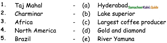
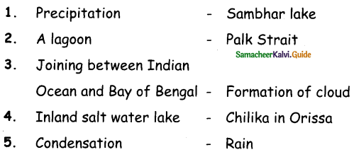
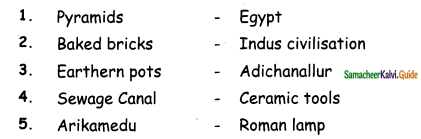
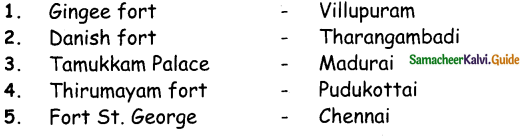
II. Match the following:
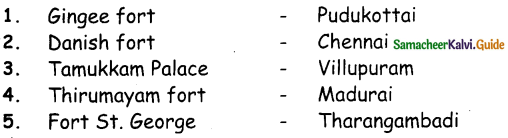
Answer:
III. True or False:
Question 1
Tamil Nadu has been ruled by many Rulers. Especially by the Chera, Chola, Pandya, and Pallava rulers.
Answer:
True
Question 2.
Vellore Fort has five mahals.
Answer:
True
Question 3.
Dindigul Fort was built by the Nayaks of Madurai.
Answer:
True
Question 4.
Oomayan Kottai is the other name for Gingee fort.
Answer:
False
Question 5.
The Padmanabhapuram Palace was built by the ruler of Travancore.
Answer:
True
![]()
IV. Answer the following:
Question 1.
What are the prime attractions of Tamil Nadu tourism?
Answer:
palaces and forts are the prime attractions of Tamil Nadu tourism.
Question 2.
Write a short note on Tharangambadi fort.
Answer:
- Tharangambadi fort is locally called Danish fort. It is located on the shores of Bay of Bengal in Tharangambadi (Tranquebar), Tamil Nadu.
- The fort is trapezoidal in shape with three rooms in the left wing.
- The central pillar of the hall holds the entire weight of the domes.
Question 3.
Name some of the tourist attractions of Gingee fort.
Answer:
Gingee Fort is a huge fort with many attractions like Kalyan Mahal, temples, Aanaikulam pond, granaries and a watchtower.
Question 4.
Give a short note on Thirumalai Nayakkar Palace.
Answer:
- Thirumalai Nayakkar Palace is a 17th-century architecture of Nayakkar dynasty. It is one of the most popular palaces in South India.
- Thirumalai Nayakkar Palace is located in the city of Madurai. This is one of the tourist spots of Tamil Nadu.
Question 5.
Who built the Thanjavur Maratha Palace? Write some of its tourist attractions.
Answer:
- Thanjavur Maratha palace was originally constructed by the rulers of Thanjavur Nayakkar kingdom.
- Thanjavur Palace Complex is a tourist attraction which houses three separate venues: the palace, the art gallery, and a manuscript library (Saraswathi Mahal).
![]()
V. Answer in detail:
Question 1.
Describe the structure of the Vellore fort.
Answer:
- Vellore Fort is a 16th-century fort situated in Vellore, Tamil Nadu. It was built by the Kings of Vijayanagara.
- Among the forts in Tamil Nadu, Vellore fort is considered to be one of the most invincible forts.
- It is surrounded by a deep and wide moat.
- The water of this moat was home to thousands of crocodiles.
- It was feared by many raiders of the fort. This fort is a good example of military architecture.
Question 2.
Write about Dindigul fort.
Answer:
- Dindigul Fort is a 17th-century hill fort situated in Dindigul, Tamil Nadu. It is also called Dindigul Malai Kottai.
- Dindigul Fort was built by the Nayakkars of Madurai, in order to defend their region from the invading Mysore army.
- Presently, the fort is maintained by the Archaeological Survey of India.
- The fort was cemented with double walls to withstand heavy artillery.
Question 3.
Describe the architecture and various sections of Padmanabhapuram Palace.
Answer:
- Padmanabhapuram Palace is a beautiful historical monument that is situated at Padmanabhapuram, Kanyakumari District. It is also known as Kalkulam Palace.
- Padmanabhapuram Palace is a wooden palace which is built in Kerala style of architecture.
- The Padmanabhapuram Palace was built by the ruler of Travancore. The palace has various sections like Queen Mother QJ Palace, Council Chamber, Southern Palace, and so on.

Activity:
Question 1.

Answer:

Prince

King

Princess
Queen
Question 2.
Connect the following objects with their names.
(Bow and Arrow, Sword, Throne, Shield, Crown)

Answer:
Throne

Crown
Shield
Bow and Arrow
Sword
Samacheer Kalvi 5th Social Science Guide Forts and Palaces Additional Questions and Answers
I. Choose the correct answer:
Question 1.
_______ are the prime attractions for tourists in Tamil Nadu.
a) Historical Places
b) Police Station
c) Hospital
Answer:
a) Historical Places
Question 2.
Vellore fort is a _______ century fort situated in Vellore.
a) 15th
b) 16th
c) 17th
Answer:
b) 16th
Question 3.
_______ fort is also called Dindigul Malai kottai.
a) Vellore
b) Gingee
c) Dindigul
Answer:
e) Dindigul
Question 4.
Thirumayam Fort is located in _______.
a) Madurai
b) Pudukottai
c) Chennai
Answer:
b) Pudukottai
Question 5.
Gingee fort is built across _______ is hills.
a) three
b) four
c) five
Answer:
a) Three
Question 6.
_______ is also known as kalkulam palace.
a) Thanjavur Maratha palace
b) Padmanabhapuram palace
c) Saraswathi mahal palace
Answer:
b) Padmanabhapuram palace
II. Fill in the blanks:
Question 1.
_______ is surrounded by a deep and wide moat.
Answer:
Vellore fort
Question 2.
Dindigul fort was cemented with double walls to withstand heavy _______.
Answer:
Artillery
Question 3.
_______ is functioning inside the George fort.
Answer:
State Secretariat
Question 4.
_______ is popular for its large rock inscriptions.
Answer:
Thirumayam fort
Question 5.
Thirumalai Nayakkar palace has an _______ museum.
Answer:
Archaeological
Question 6.
Thanjavur Maratha palace is popularly called _______.
Answer:
Thanjavur Aranmanai
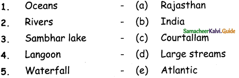
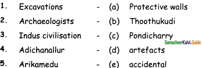
III. Match the following:
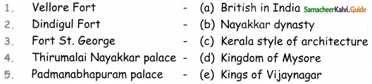
Answer:
- (e)
- (d)
- (a)
- (b)
- (c)
IV. Write True or False:
Question 1.
Cholas, Pandyas, and Nayakkars constructed magnificent forts and palaces in Tamil Nadu.
Answer:
True
Question 2.
Gingee fort is a good example of military architecture.
Answer:
False
Question 3.
Fort St. George is the first fort built by the British in India.
Answer:
True
Question 4.
Thirumayam Fort is famous for its artistic work and architectural brilliance.
Answer:
True
Question 5.
Sadras Fort is located in Madurai.
Answer:
False
Question 6.
Padmanabhapuram palace is a wooden palace which is built in kerala style of architecture.
Answer:
True
V. Answer the following:
Question 1.
What are the inside that Vellore fort?
Answer:
Inside the Vellore fort, there is a well-known temple called Jalakanteswarar temple, a church, a mosque, a museum and several government offices.
Question 2.
Name the important Mahals in Vellore fort.
Answer:
Vellore fort has five important Mahals. They are
- Hyder Mahal
- Tippu Mahal
- Begam Mahal
- Candy Mahal
- Badhusha Mahal
Question 3.
Write a short note on Fort 5t.George.
Answer:
Fort St. George is the first fort built by the British in India. Fort St. George is located in Chennai. State Secretariat is functioning inside the fort.
Question 4.
Write a short note on Tamukkarn Palace.
Answer:
Tamukkarn Palace was the summer residence. Of the Queen Rani Mangammal of Nayak dynasty. It is located in Madurai.
Question 5.
What the major attraction of Thirumalai Nayakkar Palace?
Answer:
The major attraction of Thirumalai Nayakkar Palace is the courtyard and the dancing hall.
VI. Answer in detail:
Question 1.
Describe the structure of Thirumayam fort.
Answer:
- Thirumayam Fort is famous for its artistic work and architectural brilliance.
- It is located in Pudukottai, Tamil Nadu.
- Thirumayam Fort is popular for its large rock inscriptions.
- It is also known as Oomayan Kottai.
Question 2.
Write about Saraswathi Mahal.
Answer:
- Saraswathi Mahal is considered as one of the oldest historical libraries in India.
- Saraswathi Mahal also has a museum.
- The library has more than a million manuscripts in languages like Tamil, Sanskrit, Marathi, Telugu, and Manipravalam.