Tamilnadu State Board New Syllabus Samacheer Kalvi 9th Social Science Guide Pdf Geography Chapter 2 Lithosphere – II Exogenetic Processes Text Book Back Questions and Answers, Important Questions, Notes.
Tamilnadu Samacheer Kalvi 9th Social Science Solutions Geography Chapter 2 Lithosphere – II Exogenetic Processes
Samacheer Kalvi 9th Social Science Lithosphere – II Exogenetic Processes Text Book Back Questions and Answers
I. Choose the best answer
Question 1.
The disintegration or decomposition of rocks is generally called as ___________
(a) weathering
(b) erosion
(c) transportation
(d) deposition
Answer:
(a) weathering
![]()
Question 2.
The process of the levelling up of land by means of natural agents.
(a) aggradation
(b) degradation
(c) gradation
(d) none
Answer:
(c) gradation
Question 3.
_______ is seen in the lower course of the river.
(a) Rapids
(b) Alluvial fan
(c) Delta
(d) Gorges
Answer:
(c) Delta
Question 4.
Karst topography is formed due to the action of _________
(a) Glacier
(b) Wind
(c) Sea waves
(d) Ground Water
Answer:
(d) Ground Water
Question 5.
Which one of the following is not a depositional feature of a glacier?
(a) cirque
(b) Moraines
(c) Drumlins
(d) Eskers
Answer:
(a) cirque
Question 6.
Deposits of fine silt blown by wind is called as ___________
(a) Loess
(b) Barchans
(c) Hamada
(d) Ripples
Answer:
(a) Loess
Question 7.
Stacks are formed by __________.
(a) Wave erosion
(b) River erosion
(c) Glacial erosion
(d) Wind deposion
Answer:
(a) Wave erosion
![]()
Question 8.
______ erosion is responsible for the formation of cirque
(a) wind
(b) glacial
(c) river
(d) underground water
Answer:
(b) glacial
Question 9.
Which one of the following is a second order land form?
(a) Asia
(b) Deccan Plateau
(c) Kulu valley
(d) Marina Beach.
Answer:
(b) Deccan Plateau
II. Match the following
Question 1.
- Distributaries – (i) glacial action
- Mushroom rock – (ii) action of sea wave
- Eskers – (iii) Lower course of river
- Stalactites – (iv) Aeolian process
- Cliff – (v) karst topography
Answer:
- – iii
- – iv
- – i
- – v
- – ii
III. Consider the given statements and choose the right option given below:
Question 1.
(i) ‘I’ Shaped valley is an erosional feature of the river
(ii) ‘U’ Shaped valley is an erosional feature of the glacier
(iii) ‘V’ Shaped valley is an erosional feature of the glacier
(a) (i), (ii) & (iii) are right
(b) (i) & (ii) are right
(c) (i) & (iii) are right
(d) only (i) is right
Answer:
(ii) is correct
![]()
Question 2.
Statement I: Running water is an important agent of gradation
Statement II: The work of the river depends on the slope of land on which it flows
(a) Statement I is false II is true
(b) Statement I and II are false
(c) Statement I is true II is false
(d) Statement I and II are true
Answer:
(d) Statement I and II are true
Question 3.
Statement: Limestone regions have less underground water.
Reason: Water does not percolate through limestone.
(a) The statement is right, reason is wrong.
(b) The statement is wrong, Reason is right.
(c) The statement and reason are wrong.
(d) The statement and reason are right.
Answer:
(c) The statement and reason are wrong.
IV. Answer in brief:
Question 1.
Define weathering.
Answer:
Weathering is the disintegration and decomposition of materials of the earth’s crust by their exposure to the atmosphere.
Question 2.
What do you mean by biological weathering?
Answer:
Biological weathering occurs due to the penetration and expansion of plant & roots, earthworms, burrowing animals (rabbits, rats), and some human activities.
![]()
Question 3.
Mention the three courses of a river with any two landforms associated with each course.
Answer:
The course of a river is divided into
- The Upper course – V-shaped valleys, gorges
- The middle course – Alluvial fans, flood plains
- The lower course – Delta and Estuary.
Question 4.
What are the ox-bow lakes?
Answer:
- Meanders in due course of time become almost a complete circle with narrow necks.
- This in turn gets abandoned and forms a lake.
- This is called an oxbow lake.
Question 5.
How does a sea cave differ from a sea arch?
Answer:
(a) Sea Arch:
- When two caves approach one another from either side of a headland and unite them from an arch.
- Eg: Neil Island, Andaman, and Nicobar
(b) Cave:
- Caves are hollows that are formed by the dissolution of limestone rocks when carbon dioxide in the air turns into carbonic acid after its reaction with water.
- They vary in size and shape.
- Eg: Guptadham caves in Western Bihar.
Question 6.
List out any four Karst topographical areas found in India.
Answer:
- Guptadham caves – Western Bihar
- Pandav caves Pachmuri – Madhya Pradesh
- Kutumsar – Bastar district in Chattisgarh
- Borra caves of Visakhapatnam – Andhra Pradesh
![]()
Question 7.
What do you mean by a hanging valley?
Answer:
- Hanging valleys are typically formed when the main valley has been widened and deepened by glacial erosion, leaving the side valley cut off abruptly from the main valley below.
- The steep drop from the hanging valley to the main valley floor usually creates cascading waterfalls – Eg. Yosemite falls, California, USA.
Question 8.
Define
(a) Moraine
(b) Drumlin
(c) Esker.
Answer:
(a) Moraine:
- Landforms formed by the glacial deposits of valley (or) continental glaciers are termed as moraines.
- They are of various shapes and sizes, like the ground, terminal, and lateral moraines, etc.
(b) Drumlin: Drumlins are deposits of glacial moraines that resemble giant inverted teaspoons (or) half cut eggs.
(c) Esker: Long narrow ridges composed of boulders gravel and sand deposited by streams of melting water which run parallel to a glacier are called eskers.
![]()
Question 9.
Mention the various features formed by wind erosion.
Answer:
Some of the erosional landforms of wind are
(a) Mushroom rocks
(b) Inselbergs and
(c) Yardangs.
(a) Mushroom rocks:
- When a rock’s bottom is soft, the sand-laden winds blow against it and wear it down.
- By the constant wearing down action of the wind, the bottom gets eroded away to form a mushroom like structure.
(b) Inselbergs:
- Certain hard rocks like igneous rocks are more resistant to wind action.
- Such isolated residual hills rising abrupt by from their surroundings are turned as inselbergs.
(c) Yardangs:
- In arid regions, certain rocks have hard and soft layers arranged vertically.
- When winds blow over these rocks, the soft layers get eroded leaving irregular crests. These are called yardangs.
Question 10.
What is a wave-cut platform?
Answer:
Flat surface found at the foot of the sea cliffs are called as wave-cut platforms, the wave-cut platform is also referred to as beach, shelf, terrace, and plain.
V. Give Reasons.
Question 1.
Chemical weathering is predominant in hot and humid zones.
Answer:
Chemical weathering predominant in hot and humid zones because
- Heat speeds up chemical weathering.
- Minerals can react with oxygen in the atmosphere or water from rain – even occasional rain in arid zones – to change their chemical composition.
- Metallic silicate minerals such as iron-containing olivine, oxidize to form hematite, a red coloured iron oxide that coats rocks.
- It is present in desert sands as laterite soil.
- With continuing heat and moisture, hematite hydrates to form yellow coloured iron oxide, limonite.
![]()
Question 2.
Silt deposits are less at estuaries than deltas.
Answer:
Silt deposits are less at estuaries than deltas because the waves keep on eroding the deposits.
e.g., River Narmada & Tapti.
Question 3.
The snow line is at the sea level in polar regions.
Answer:
- The snow line is an irregular line located along the ground surface where the accumulation of snowfall equals ablation (melting and evaporation).
- This line varies greatly in altitude and depends on several influences.
- Where temperatures are low, as near the poles, the snowline is quite low in elevation.
- Where temperatures are high, as near the Equator the snowline is very high.
- Therefore snowline is at the sea level in polar regions.
Question 4.
Wind can possibly erode the rocks from all sides.
Answer:
Wind can possibly erode the rocks from all sides, because
- when a rock’s bottom is soft, the constant wearing down action of the wind, the bottom gets eroded away to form a mushroom-like structure.
- Certain hard rocks like igneous rocks are more resistant to wind action. Isolated residual hills are formed from their surroundings.
- When winds blow over the hard and soft layers of rocks the soft layers get eroded leaving irregular crests.
Question 5.
In limestone regions, surface drainage is rarely found.
Answer:
- The rainwater mixes with CO2 and enters into the limestone region it dissolves and destroys much of the lime stone.
- Subterranean drainage may limit surface water with few to no rivers.
- The ability of water to penetrate the rock lowers. Joints and bedding planes make the rock permeable. So surface drainage is rarely found.
VI. Distinguish between:
Question 1.
Physical and chemical weathering.
Answer:
Physical weathering
- It is the breakdown of rocks without changing their chemical composition, through the action of physical forces.
- The constant freezing and thawing of rocks during the night and day leads to the expansion and contraction of rocks.
- Exfoliation, block disintegration, granular disintegration etc., are the different types of weathering.
Chemical weathering
- Disintegration and decomposition of rocks due to chemical reactions is called chemical weathering.
- This is predominantly high in the hot and humid regions such as the equatorial, tropical and sub tropical zones.
- Chemical weathering takes place through the processes of oxidation, carbonation, solution and hydration.
![]()
Question 2.
Delta and Estuary
Answer:
Delta
- A triangular shpaed low lying area formed by the river at its mouth is called delta.
- Deltas have fine deposits of sediments enriched with minerals.
- Eg: Cauvery delta in Tamil Nadu.
Estuary
- Estuary is formed, where the rivers meet the sea.
- Deposition of silt by the river is not possible here since the waves keep on eroding the deposits.
- Eg: River Narmada and Tapti.
Question 3.
Stalactite and stalagmite.
Answer:
Stalactites:
- When the water containing dissolved calcite gradually drips from the ceiling of the caves, water evaporates and the remaining calcite hangs from the ceiling. Thus stalactites are formed.
- Remember stalactites with ‘C’ meaning coming from ceiling.
- Limestone stalactites form extremely slowly, usually less than 10 cm every 1000 years.
Stalagmites:
- When the calcite deposits rise upward like a pillar stalagmites are formed.
- Remember stalagmites with ‘G’ coming from the ground.
- The stalagmite formation occurs only under certain conditions within the underground cavern.
Question 4.
Longitudinal and Transverse sand dunes.
Answer:
Longitudinal sand dune:
- Longitudinal dunes are long narrow ridges of sand.
- They extend in a direction parallel to the prevailing winds.
- These dunes are called seifs in Sahara.
Transverse sand dune:
- Transverse dunes are asymmetrical in shape.
- They are formed by alternate slow and fast winds.
- These winds blow from the same direction.
![]()
Question 5.
Inselbergs and yardangs
Answer:
Inselbergs:
- Inselberg means an Island mountain.
- It is an isolated residual hills rising abruptly from their surroundings.
- Eg. Uluru or Ayers rock, Australia
Yardangs:
- Yardangs are formed in arid regions.
- Here, certain rocks have hard and soft layers arranged vertically.
- When winds blow over these rocks, the soft layers get eroded leaving irregular crests called Yardangs.
Question 6.
Spit and bar.
Answer:
Spit:
- A spit is a ridge or embankment of sediment, attached to the land on one end and terminating in open water on the other end.
- Spits are common at the mouth of estuaries. Eg. Kakinada spit
Bar:
- A bar is an elongated deposit of sand, shingle or mud found in the sea, almost parallel to the shoreline.
- Where a spit grows across a bay, a bar is formed.
VII. Answer in a Paragraph:
Question 1.
Write a note on weathering classify and explain.
Answer:
- Weathering is the disintegration and decomposition of materials of the earth’s crust by their exposure to the atmosphere.
- The movement of huge volumes of weathered rock material down the slope due to gravity is called mass movement or mass wastage.
- The nature and magnitude of weathering differs from place to place and region to region
- There are three types of weathering called physical weathering, Chemical weathering and Biological weathering
(a) Physical weathering:
- It is the breakdown of rocks without changing their chemical composition, through the action of physical forces.
- The constant freezing and thawing of rocks during the night and day leads to expansions and contractions of rocks.
- Exfoliation, block disintegration, granular disintegration, etc., are the different types of weathering.
- The alternate heating and cooling on rounded rock surfaces leads to the peeling of rocks, layer by layer. This is called exfoliation.
- Granular disintegration takes place in crystalline rocks where the grains of the rocks became loose and fall out.
- Block disintegration is caused due to repeated expansion and contraction of rocks day and night.
(b) Chemical weathering:
- Disintegration and decomposition of rocks due to chemical reactions is called chemical weathering.
- Chemical weathering takes place through the processes of oxidation carbonation, solution and Hydration.
- Oxygen in the atmosphere reacts with the iron found in rocks, forming iron oxide. This process is known as oxidation.
- Carbonation in the mixing of water with the atmospheric carbon di – oxide forming carbonic acid.
- Solution is the process of dissolution of rock substances in water. This results in the loosening of the rock particles.
- Certain chemicals in the rock enlarge in size in humid conditions, resulting in the development of cracks and the rock wears down. This is known as hydration.
- Biological weathering: Biological weathering occurs due to the penetration and expansion of plant roots, earthworms, burrowing animals (rabbits, rats) and some human activities.
![]()
Question 2.
Explain the erosional landforms formed by underground water.
Answer:
Most erosion takes place due to the process of solution. When rainwater mixes with carbon-di-oxide and enters a limestone region, it dissolves and destroys much of the limestone. As a result, landforms such as Terra Rossa, Lappies, sinkholes, swallow holes, dolines, uvalas, poljes, caves and caverns are formed.
Terra Rossa (Italian term for Red soil): The deposition of red clay soil on the surface of the Earth is due to the dissolution of limestone content in rocks. The redness of the soil is due to the presence of iron oxide.
Lappies: When the joints of limestone rocks are corrugated by groundwater, long furrows are formed and these are called LAPPIES.
Sinkhole: Funnel-shaped depressions formed due to the dissolution of limestone rock is called sinkholes. Their average depth ranges between three and nine meters.
Caves and Caverns: Caves and caverns are subterranean features of karst topography. Caves are hollows that are formed by the dissolution of limestone rocks when carbon dioxide in air turns into carbonic acid after its reaction with water. They vary in size and shape. Caverns are the caves with irregular floors, e.g., Guptadham caves in Western Bihar.
All types of deposits in the caves and caverns are collectively called speleothems which include travertines, tufa, dripstones.
Swallow Holes, Uvalas, Dolines, Poljis are other erosional Features of karst regions that predominate in other parts of the world.
Question 3.
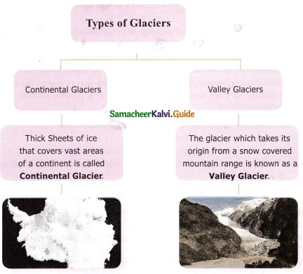
What is a glacier? Explain its types,
Answer:
(a) Glacier:
- A glacier is a large mass of ice that moves slowly over the land, from its place of accumulation. It is also known as ‘River of ice’.
- The place of accumulation is called snowfield.
- The height above which there is a permanent snow cover in the higher altitude or latitude is called snowline.
- The gradual transformation of snow into granular ice is called ‘fim’ or ‘neve’ and finally it becomes solid glacial ice.
- The large mass of ice creates pressure at its bottom and generates heat. Due to this, the glacier melts a little and starts to move.
(b) Types of glaciers: Glaciers are broadly divided into two types based on the place of occurrence, such as Continental glacier and Valley glacier.
Question 4.
Describe the depositional work of winds.
Answer:
Deposition occurs when the speed of the wind is reduced by the presence of obstacles like bushes, forests, and rock structures. The sediments carried by wind get deposited on both the windward and leeward sides of these obstacles.
Some of the depositional landforms are sand dunes, barchans, and loess.
Sand Dune: In deserts, during sandstorms, the wind carries loads of sand. When the speed of wind decreases, the huge amount of sand gets deposited. These mounds or hills of sand are called sand dunes. There are different types of sand dunes.
Barchan: Barchans are isolated, crescent-shaped sand dunes. They have gentle slopes on the windward side and steep slopes on the leeward side.
Transverse Dunes: Transverse dunes are asymmetrical in shape. They are formed by alternate slow and fast winds that blow from the same direction.
Longitudinal Dunes: Longitudinal dunes are long narrow ridges of sand, which extend in a direction parallel to the prevailing winds. These dunes are called Seifs in Sahara.
Loess: The term loess refers to the deposits of fine silt and porous sand over a vast region. Extensive loess deposits are found in Northern and Western China, the Pampas of Argentina, in Ukraine, and in the Mississippi Valley of the United States.
![]()
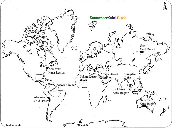
VIII. Map Skill
Question 1.
On the given outline map of the world, mark the following.
- Any two deltas
- A Karst region
- Any two hot and cold deserts
IX. HOTS Questions.
Question 1.
Is wind the only gradational agent in the desert?
Answer:
- Deserts are areas with little or no rainfall.
- Therefore we find only limited or non-existent plant (animal) life.
- Due to the lack of moisture, chemical weathering is almost absent.
- Mechanical weathering is the dominant activity.
- Wind obviously becomes the only major agent of erosion, transportation, and deposition.
- Wind can blow without any obstructions of trees etc.
- Wind is also supplied with a fine dust which helps carve the landforms.
- Flowing water is an occasional agent of erosion whenever there are heavy showers followed by flash floods.
- Such showers are very rare.
![]()
Question 2.
Underground water is more common in limestone areas than surface runoff. Why?
Answer:
- The underground flow of water is more common than surface water in the limestone areas.
- It is because the chief constituent of limestone is calcium carbonate which is soluble in pure water.
- It is easily soluble in carbonated water.
- Surface runoffs and infiltration into the ground start the solution process along with the fractures and joints.
Question 3.
The river channels in the lower course are wider than the upper course.
Answer:
- In the lower course of the river the gradient is gentler than in the upper course.
- The river has more energy and the volume amount of water is high.
- In the lower course, there is more lateral (sideways) erosion.
- The channel is wide and deep.
- The river has less friction to overcome which means that the river can flow faster.
- As the river erodes sideways, it swings from side to side forming large bends called meanders.
- Erosion is the most dominant action of the river in the upper course.
- In the lower course, the river moving downstream across a broad, level plain is loaded with debris brought down from its upper and middle courses.
- Therefore the river channels are wider in the lower course compared to the upper course.
X. Give geographical terms for the following
(a) Chemical alteration of carbonate rocks on limestone region.
Answer:
Karst topography
(b) Flat surfaces near cliffs.
Answer:
Wave cut platforms
(c) Erosion + Transportation + Deposition
Answer:
Gradation
(d) The bottom line of a snowfield.
Answer:
Snowline
Intext Activity
Question 1.
Take a trough filled with sand, empty a portion of sand in the middle and fill it with sugar. Now level the sand over the sugar. Pour water into the trough and observe what happens. The sugar dissolves and forms a depression. This is similar to the formation of a sinkhole.
Answer:
Activity to be done by the students themselves.
Question 2.
Fake Snow
Materials needed
- A cup of Baking Soda
- Shaving Cream
Method
- Pour one cup of baking soda
- Spray the shaving cream
The snow will start forming almost immediately.
Answer:
Activity to be done by the students themselves
Question 3.
Discuss in small groups the effects of global warming
Answer:
Activity to be done by the students themselves
Intext Hots
Question 1.
Is weathering a pre-requisite in the formation of soil?
Answer:
(a) Weathering is a key part of the process of soil formation, and the soil is critical to our existence on Earth.
(b) Soil is a complex mixture of minerals (approximately 45%), organic matter (approximately 5%), and empty space (approximately 50%, filled to varying degrees with air and water).
The mineral content of soils is variable but is dominated by clay minerals and quartz, along with minor amounts of feldspar and small fragments of rock. The types of weathering that take place within a region have a major influence on soil composition and texture. For example, in a warm climate, where chemical weathering dominates, soils tend to be richer in clay
(c) Soils develop because of the weathering of materials on Earth’s surface, including the mechanical breakup of rocks, and the chemical weathering of minerals. Chemical weathering reactions (especially the formation of clay minerals) and biochemical reactions proceed
![]()
Question 2.
The snowline of Alps is 2700 metre whereas the snowline of Greenland is just 600 metre. Find out the reason.
Answer:
- Snowline is the altitude which delimits the low levels of permanent snow.
- Snowline changes due to a lot of factors including their distance from the equator or tropics.
- Alps mountain range is closer to tropics and shows snowline of 2700 metres.
- Greenland is near the North Pole and it’s the biggest reason for a snowline of 600 metres.
Samacheer Kalvi 9th Social Science Outbreak of World War II and Its Aftermath Additional Important Questions and Answers
I. Choose the correct answer
Question 1.
The breakdown of rocks without changing their chemical composition is called
(a) physical weathering
(b) chemical weathering
(c) Aggradation
(d) Degradation
Answer:
(a) physical weathering
Question 2.
Mixing of water with the atmospheric carbon-di-oxide is known as
(a) Oxidation
(b) Carbonation
(c) Exfoliation
(d) Solution
Answer:
(b) Carbonation
Question 3.
Hydration comes under
(a) Physical weathering
(b) Biological weathering
(c) Chemical weathering
(d) mass movement
Answer:
(c) Chemical weathering
![]()
Question 4.
The shallow fast flowing water in a stream is called a
(a) Waterfall
(b) Plunge pool
(c) Rapid
(d) Gorge
Answer:
(c) Rapid
Question 5.
Where the rivers meet the sea is formed.
(a) Delta
(b) Flood plains
(c) Estuary
(d) Alluvial fan
Answer:
(c) Estuary
Question 6.
Karst Topography is found mainly in regions characterised by
(a) Alluvial fans
(b) Glacial outwash plains
(c) Limestone bedrock
(d) Loess
Answer:
(c) Limestone bedrock
![]()
Question 7.
The Grand Canyon was formed by
(a) River erosion
(b) Rain erosion
(c) Wind erosion
(d) Karst topography
Answer:
(a) River erosion
Question 8.
Sinkholes and caves are created when limestone formations are dissolved by
(a) Weak carbonic acid contained in the ground
(b) Strong hydrochloric acid from my runoff
(c) Strong hypochlorite from acid rain
(d) Weak Sulphuric acid from animal remains
Answer:
(a) Weak carbonic acid contained in ground
Question 9.
Which structure is most similar to an alluvial fan in formation and composition
(a) River
(b) Watershed
(c) Delta
(d) Lake
Answer:
(c) Delta
Question 10.
What type of erosion produces rounded valleys?
(a) River
(b) Wind
(c) Wave
(d) Glacial
Answer:
(d) Glacial
Question 11.
Speleothems means
(a) Travertines
(b) Tufa
(c) Dripstones
(d) All the three
Answer:
(d) All the three
![]()
Question 12.
Stalactites and stalagmites meet together to form
(a) Columns
(b) Cirque
(c) Matterhorn
(d) Arete
Answer:
(a) Columns
II. Match the Following
Question 1.
- Physical weathering – (a) Oxidation
- Chemical weathering – (b) Rock slide
- Biological weathering – (c) Solar energy
- Mass movement – (d) Exfoliation
- External process – (e) Human activities
Answer:
- – (d)
- – (a)
- – (e)
- – (b)
- – (c)
Question 2.
- Upper course – (a) Mouth
- Origin of a river – (b) Flood plains
- River joining the sea – (c) Delta
- Middle course – (d) Spurs
- Lower course – (e) Source
Answer:
- – (d)
- – (e)
- – (a)
- – (b)
- – (c)
Question 3.
- Alluvial fan – (a) Subsurface water
- Flood plains – (b) Foothills
- Delta – (c) Non-porous
- Ground water – (d) Triangular shaped
- Impermeable rocks – (e) River banks
Answer:
- – (b)
- – (e)
- – (d)
- – (a)
- – (c)
Question 4.
- Cirque Arete – (a) Large
- Arete – (b) Party
- Matterhorn – (c) Bowl-shaped arm chair
- Glacier – (d) Pyramidal peaks
- Fjords – (e) Narrow knife like ridges
Answer:
- – (c)
- – (e)
- – (d)
- – (a)
- – (b)
![]()
Question 5.
- Beach – Old man of Hoy, Scotland
- Sea stack – Flat surface
- Sea Arch – A ridge Juhu
- Wave cut platform – Mumbai
- Spit – Neil Island
Answer:
- – (d)
- – (a)
- – (e)
- – (b)
- – (c)
III. Answer in Brief
Question 1.
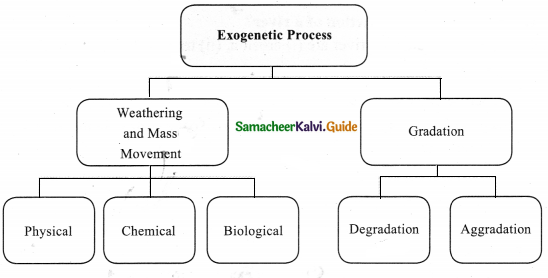
Explain the Exogenetic process with a diagram.
Answer:
All deformation on the face of the Earth is due to the continuous influence of various forces on the earth’s surface.
Question 2.
How is the structure of the earth’s surface controlled?
Answer:
- The earth is a dynamic system that undergoes various changes due to internal and external processes.
- The continuous interactions of these two processes control the structure of the earth’s surface.
Question 3.
Mention the cause for external and internal processes.
Answer:
- The external processes are the consequence of solar energy and gravitational forces.
- The internal processes are an outcome of the earth’s internal heat.
Question 4.
What is the mass movement?
Answer:
The movement of huge volumes of weathered rock materials down the slope due to gravity is called mass movement or mass wastage.
Example:
- Rockslide
- landslide
- debris fall
- mudflow.
![]()
Question 5.
What is Exfoliation?
Answer:
The alternate heating and cooling on rounded rock surfaces lead to the peeling of rocks, layer by layer like an onion.
This is called exfoliation. Sheeting and shattering are the other forms of exfoliation.
Question 6.
Define soil.
Answer:
- The disintegrated rock materials, in due course of time, are weathered further to form soil
- Soil is a mixture of disintegrated rocky material and decayed organic matter called humus.
Question 7.
Mention the agents of chemical weathering.
Answer:
The agents of chemical weathering are oxygen, carbon-di-oxide, and hydrogen.
Question 8.
What is gradation?
Answer:
- Gradation is the process of levelling of the land by means of natural agents like rivers, groundwater, winds, glaciers, and sea waves.
- These agents produce various gradational relief features in due course of time.
- Graduation takes place in two ways (a) degradation and aggradation.
Question 9.
What is the primary function of a river?
Answer:
The primary functions of a river are
- erosion
- transportation
- deposition.
![]()
Question 10.
How are springs caused?
- The permeable rocks allow water to percolate.
- This percolated water in course of time returns to the surface in the form of springs, geysers, hot springs, etc.
Question 11.
Explain the term, Terra Rossa.
Answer:
- Terra Rossa is the Italian term for Red soil.
- The deposition of red clay soil on the surface of the Earth is due to the dissolution of limestone content in rocks.
- The redness of the soil is due to the presence of iron oxide.
Question 12.
How are stalactites formed?
Answer:
- When the water containing dissolved calcite gradually drips from the ceiling of the caves, water evaporates and the remaining calcite hangs from the ceiling.
- Thus Stalactites are formed.
Question 13.
What is a continental glacier?
Answer:
Thick sheets of ice that covers vast areas of a continent are called a continental glacier.
Question 14.
What is a valley glacier?
Answer:
The glacier which takes its origin from a snow-covered mountain range is known as a valley glacier.
Question 15.
What is a matter horn?
Answer:
The pyramidal peaks formed when three or more cirques meet together are referred to as Matterhoms.
Question 16.
How are mushrooms formed?
Answer:
- Rocks are made up of hard and soft layers.
- When a rock’s bottom is soft, the sand-laden winds blow against it and wear it down.
- By the constant wearing down action of the wind, the bottom gets eroded away to form a mushroom-like structure.
- This is called a mushroom or pedestal rock.
- Such rocks are found near Jodhpur in Rajasthan.
Question 17.
Define waves.
Answer:
- A steady up (crest) and down (trough) movement of surface water are called waves.
- Sea waves are the most powerful agents of gradation.
- Their erosional, transportation and depositional processes are confined to a very narrow belt along the coastal areas.
![]()
Question 18.
What is snowline?
Answer:
The height above which there is a permanent snow cover in the higher altitude or latitude is
IV. Answer in as Paragraph.
Question 1.
Write about the erosional and depositional landforms of waves.
Answer:
(a) Erosional landforms of waves.
- Sea Cave: Prolonged wave attack on the base of a cliff erodes rock materials, which results in the formation of caves.
- Sea Arch: When two caves approach one another from either side of a headland and unite, they form an arch.
- Sea Stack: Further erosion by waves ultimately leads to the total collapse of arch. The seaword portion of the headland will remain as a pillar of rock known as stack.
- Sea Cliffs: Sea cliffs are strep rock faces formed when sea waves dash against them. The rocks get eroded to form steep vertical walls.
- Wave cut platforms: Flat surface found at the foot of sea cliffs are called wave cut platforms.
(b) Depositional landforms of waves.
- Beach: Sand and gravel are moved and deposited by waves along the shore to form j beaches. This is the most dominant and constructive work of the sea. Eg. Marina beach, Chennai.
- Bar: A bar is an elongated deposit of sand, shingler or mud found in the sea, almost j parallel to the shoreline.
- Spit: A spit is a ridge or embankment of sediment, attached to the land on one end j and terminating in open water on the other end.
V. Distinguish between
Question 1.
Distinguish between Granular disintegration and Block disintegration
Answer:
Granular Disintegration:
- Granular disintegration takes place in crystalline rocks.
- Here the grains of the rocks become loose and fall out.
Block Disintegration:
- Repeated expansion and contradiction of rocks during day and night respectively causes stress on the joints of the rocks.
- This results in Block disintegration.
![]()
Question 2.
Distin guish between Oxidation and Carbonation
Answer:
Oxidation:
- Oxygen in the atmosphere reacts with the iron found in rocks.
- It leads to the formation of iron-oxide.
- This process is known as oxidation.
- It results in the weakening of rocks.
Carbonation:
- Carbonation is the mixing of water with the atmospheric carbon-di-oxide.
- As a result carbonic acid is formed.
- Carbonation is important in the formation of caves, in limestone region.
- When the carbonic acid reacts with the carbonate rocks, the rocks get disintegrated.
Question 3.
Distinguish between Solution and Hydration
Answer:
Solution:
- Solution is the process of a dissolution of rock substances in water.
- This process loosens the rock particles.
- This in turn breaks down the rocks.
Hydration:
- Certain chemicals in the rock enlarge in size in humid conditions.
- These minerals found in the rock swell resulting in the development of cracks.
- This type of weathering is called hydration.
Question 4.
Distinguish between Degradation and Aggredation
Answer:
Degradation:
- Gradation is the process of levelling of the land by means of natural agents.
- Degradation or denudation is the wearing down of the land surface by various natural agents.
Aggredation
- Natural agents like rivers, ground water, winds, glaciers and sea waves cause gradation.
- Aggradation is building up of landforms due to national agents.
Question 5.
Distinguish between Tributary and Distributary
Answer:
Tributary
- Small streams that join the main river is called tributary.
- Eg: River Bhavani
Distributary
- River channels that get separated from the main river is called a distributary.
- Eg: River Kollidam
![]()
Question 6.
Distinguish between Gorges and Canyons
Answer:
Gorges:
- When the river flows through a mountainous region made up of hard rocks, it forms a valley with almost vertical sides called gorge.
- In India, deep gorges have been formed by Brahmaputra and Indus with the Himalayas,
Canyons:
- A deep gorge with steep sides that runs for hundreds of kilometres is referred to as a canyon.
- Grand canyon of the river Colorado in the USA is an example.
Question 7.
Distinguish between Lappies and Sinkholes
Answer:
Lappies:
- The joints of limestone rocks are corrugated by groundwater.
- This results in the formation of long furrows called Lappies.
Sinkholes:
- Funnel-shaped depression formed due to the dissolution of limestone rock is called sinkholes.
- Their average depth ranges between three and nine meters.
Question 8.
Distinguish between V-shaped valley and U-shaped valley
Answer:
V-shaped valley:
- It is an erosional landform of a river.
- A V-shaped valley is formed by the vertical erosion of the river.
- The valley is deepened and widened.
U-shaped valley:
- It is an erosional landform of a glacier.
- When the glacier moves down along a river valley the valley, further gets eroded deep and wide.
- Thus U-shaped valley is formed.
Question 9.
Distinguish between Moraines and Outwash plain
Answer:
Moraines
- Landforms formed by the glacial deposits of the valley or continental glaciers are termed as moraines.
- They are of various shapes and sizes, like the ground, terminal, and lateral moraines etc.
Outwash plain
- An outwash plain consists of glacial sediments deposited by the melting ice at the terminus of a glacier.
- It appears as an extensive accumulation of sand, gravel, and silt.
Question 10.
Distinguish between Barchans and Loess
Answer:
Barchans:
- Barchans are isolated crescent-shaped sand dunes.
- They have gentle slopes on the windward side and steep slopes on the leeward side.
Loess:
- The term loess refers to the deposits of fine silt and porous sand over a vast region.
- Extensive loess deposits are found in Northern and Western China, the Pampas of Argentina, in Ukraine, and in the Mississippi valley of the United States.
VI. Give reasons
Question 1.
Physical weathering causes cracks on the surface of the earth.
Answer:
- The constant freezing and thawing of the rocks during the night and day leads to the expansion and contraction of rocks under physical weathering.
- So cracks are formed and disintegration occurs.
Question 2.
The predominant action of a river in the middle course is transportation. Why?
Answer:
- The river enters the plain in its middle course.
- The volume of water increases with the confluence of many tributaries.
- This increases the load of the river.
- Thus, the predominant action of a river is transportation.
Question 3.
Flood plains are fertile,
Answer:
- Fine sediments are deposited on river banks when a river floods.
- These sediments make the region rich and fertile.
- Hence flood plains are fertile,
Question 4.
Most erosion takes place due to the process of the solution with underground water.
Answer:
Most of the erosion takes place due to the process of the solution because
- When rain water mixes with carbon-di-oxide and enters into a limestone region, it dissolves and destroys much of the limestone.
- As a result landforms such as Terrarossa, Lappies, sinkholes, swallow holes, Uvalas, poljes, caves, and caverns are formed.
VII. Consider the given statements and choose the right option given below:
Question 1.
Statement I: The Earth undergoes various changes due to internal and external processes.
Statement II: The external processes are the consequence of solar energy and gravitational forces.
Answer:
(i) Statement I and II are true.
(ii) Statement I is true, II is false.?
(iii) Statement II is true, I is false.
(iv) Statement I and II are false.
Answer:
(i) Statement I and II are true.
![]()
Question 2.
Statement: The Agents of chemical weathering are Oxygen, Carbon dioxide, and Hydrogen.
Reason: Chemical weathering is predominantly high in the hot and humid regions.
Answer:
(i) Statement is true, Reason is wrong
(ii) Statement is wrong, Reason is true
(iii) Statement and Reason are wrong
(iv) Statement and Reason are true
Answer:
(iv) Statement and Reason are true
Question 3.
Statement: Erosion is the most dominant action of the river with the upper course.
Reason: Deep gorges have been formed by Brahmaputra and Indus in the Himalayas.
Answer:
(i) Statement and Reason are true
(ii) Statement and Reason are wrong
(iii) Statement is true, Reason is wrong
(iv) Reason is true, statement is wrong
Answer:
(i) Statement and Reason are true
Question 4.
Statement I: Groundwater is an active agent in limestone regions.
Statement II: Deposition of red clay soil on the surface of the earth is known as Lappies.
Answer:
(i) Statement I & II are true.
(ii) Statement I is true and Statement II is wrong
(iii) Both the statements are wrong.
(iv) Statement I is wrong and Statement II is true
Answer:
(ii) Statement I is true and Statement II is wrong]
VIII. Hots
Question 1.
Glaciers do not form deep narrow valleys. Why?
Answer:
- The Glaciers form U-shaped valleys with steep, straight sides and a flat or rounded bottom.
- It is in contrast to the valleys carved by rivers to be V-shaped in cross-section.
- Glaciated valleys are formed when a glacier travels across and down a slope, carving the valley by the action of scouring.
- So glaciers do not form deep narrow valleys.
Question 2.
What are Swallow holes, Uvalas, Dolines, Travertines, Tufa, dripstones?
Answer:
(a) Swallow holes: It is a depression in the ground communicating with a subterranean passage (especially in limestone) and formed by solution or by a collapse of a cavern roof.
(b) Uvalas: It is a local term used by people in some regions in Croatia, Bosnia and Herzegovina, Montenegro, and Serbia. In geoscience, it denotes a closed karst depression, a terrain form usually of elongated or compound structure and of larger size than that of sinkholes.
(c) Dolines: Dolines are funnel-shaped depressions of the ground surface formed by solution in limestone regions.
(d) Travertines: Travertine is a form of limestone deposited by mineral springs, especially hot springs. It is formed by a process of rapid precipitation of calcium carbonate, often at the mouth of a hot spring or in a limestone cave.
(e) Tufa: It is a variety of limestone formed when carbonate minerals precipitate out of ambient temperature water.
(f) Dripstones: Rock deposited by precipitation from dripping water such as that which forms stalactites and stalagmites.
![]()
Question 3.
What are the uses of limestone?
Answer:
- Limestone is a sedimentary rock.
- It has numerous uses, such as:
(a) a building material
(b) an essential component of concrete
(c) aggregate for the base of roads.
(d) white pigment or filler in products such as toothpaste or paints.
(e) chemical feed stock for the production of lime.
(f) a soil conditioner or a popular decorative addition to rock gardens.
IX. Give geographical terms for the following
- The river falls vertically from a steep slope ________
- Shallow fast flowing water in a stream ________
- River forming sweeping loops and bends ________
- Caves with irregular floors ________
- Calcite deposits rising upwards like a pillar ________
- The gradual transformation of snow into granular ice ________
- Glacial valleys that are partly submerged in the sea ________
Answers:
- Waterfall
- Rapid
- Meanders
- Caverns
- Stalagmite
- Firn or Neve
- Fjords