Tamilnadu State Board New Syllabus Samacheer Kalvi 7th Social Science Guide Pdf Geography Term 3 Chapter 1 Exploring Continents – North America and South America Text Book Back Questions and Answers, Notes.
Tamilnadu Samacheer Kalvi 7th Social Science Solutions Geography Term 3 Chapter 1 Exploring Continents – North America and South America
7th Social Science Guide Exploring Continents – North America and South America Text Book Back Questions and Answers
I. Choose the correct answer:
Question 1.
The ………………….. separates North America from Asia.
a) Bering Strait
b) Palk Strait
c) Malacca Strait
d) Gibraltar straits
Answer:
a) Bering Strait
![]()
Question 2.
………………….. is known as the “sugar bowl of the world”.
a) Mexico
b) USA
c) Canada
d) Cuba
Answer:
d) Cuba
Question 3.
………………….. are the longest rivers in North America.
a) The Mississippi and Missouri rivers
b) The Mackenzie river
c) The St. Lawrence river
d) The Colorado river
Answer:
a) The Mississippi and Missouri rivers
Question 4.
………………….. is the longest mountain chain in the world.
a) The Andes
b) The Rockies
c) The Himalayas
d) The Alps
Answer:
a) The Andes
![]()
Question 5.
………………….. basin gets rainfall every day because of its equatorial location
a) The Mackenzie
b) The Orinoco
c) The Amazon
d) The Parana
Answer:
c) The Amazon
II. Fill in the blanks:
1. ………………….. 86 m below the sea level is the lowest part of the continent of North America.
Answer:
Death valley
2.
………………….. is one of the world’s best fishing grounds.
Answer:
Grand bank
![]()
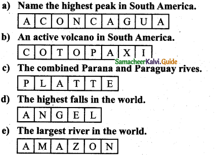
3. The highest peak in the Andes is ………………….. on the Chile – Argentina border.
Answer:
Mount Aconcagua
4. ………………….. of the equatorial regions are called the “lungs of the world”.
Answer:
The selvas
5. …………………. is also known as the “coffee pot” of the world.
Answer:
Minas Gersals and Sao paulo
![]()
III. Match the following:
| A | B |
| 1. Mount McKinley | a) Tropical forests |
| 2. Grand Canyon | b) The flightless bird |
| 3. Ebony | c) The Colorado River |
| 4. 4’o Clock Rains | d) 6194 m |
| 5. Rhea | e) The equatorial regions |
Answer:
| A | B |
| 1. Mount McKinley | d) 6194 m |
| 2. Grand Canyon | c) The Colorado River |
| 3. Ebony | a) Tropical forests |
| 4. 4’o Clock Rains | e) The equatorial regions |
| 5. Rhea | b) The flightless bird |
IV. Give the Reasons:
Question 1.
The eastern coast of North America particularly the USA enjoys a mild climate.
Answer:
The South and east are usually warm all the year round and regions around the mouth of the Mississippi – Missouri and the Gulf Coast have summer rain from the North East Trades which blow onshore in summer.
![]()
Question 2.
The United States of America is known as “Melting Pot”.
Answer:
The United States of America is known as a “Melting pot” where hundreds of different cultures meet, blend, and create a new culture.
Question 3.
Though Quito and Amazon basin are in the same latitude Quito enjoys eternal Spring. Whereas the Amazon basin is hot.
Answer:
- The Climatic of the continent of South America has been closely influenced by the latitudes, altitudes, and the proximity of the Pacific and Atlantic Oceans.
- It is hot in the Amazon basin as the equator passes through it whereas Quito situated almost on the
same latitude on the Andes has Eternal Spring - That is, it has a pleasant climate throughout the year because of its high altitude at 9,350 feet or 2849.88 the meter above the sea level.
Question 4.
Peru is one of the world’s largest producers of tròpical fish.
Answer:
- Peru is one of the world’s largest producers of tropical fish. Here the cool Humboldt Current helps in bring planicton, which is the main food for fishes.
- Commercial deep-sea fishing off of Peru’s coastal belt over 3000 km.
V. Distinguish between
Question 1.
The Rocky Mountain and the Appalachian mountain.
Answer:
Rocky mountain
- The western part of North America is occupied by long ranges of young fold mountains known as Rocky mountains
- The Width varies from 110 to 480 Kms.
- The Rocky Mountains are west of the Mississippi River.
![]()
Appalachian mountain
- The eastern part of North America formed of old fold Appalachian which is not continuous like the Rockies.
- There are few peaks more than 1800m high.
- The Appalachian Mountain is east of the river.
Question 2.
The Prairies and the Pampas grassland.
Answer:
Prairies grassland:
- The temperature grasslands of North America are known as prairies.
- Region – Central USA and Central Canada.
- Winter is very cold, Summer is hot and rainfall is moderate.
Pampas grassland:
- The temperature grasslands of South America are known as pampas.
- Region – North of Eastern part of Argentina, Uruguay and Southernmost Brazil.
- Summer is quite warm and winter is cold and moderate rainfall.
Question 3.
Tundra and Taiga.
Answer:
Tundra
- Region – Northern coast of Canada and the Northern islands.
- Climate – Winter is long and Severely cold, Summer is short and cool. Rainfall is scanty.
- Flora – Mosses, Lichens, and Dwarf willows.
Taiga :
- Region – The coniferous forests are found in Alaska and Canada, South Central Alaska and North Eastern Canada.
- Climate – Winter is very cold, Summer is warm and short. Heavy snowfall in winter.
- Flora – Pine, Fir, Cedar and Spruce.
![]()
VI. Put (✓) for the correct option:
Question 1.
Assertion (A) : Cotton grows well in southern and western states of North America.
Reason (R) : Warm summer with frequent rainfall and fertile soil which provide favourable condition.
a) Both A and R is correct.
b) A is correct and R is wrong,
c) A is wrong and R is correct
d) Both A and R is wrong
Answer:
a) Both A and R is correct.
Question 2.
Assertion (A) : Industries in South America have developed rapidly.
Reason (R) : The continent lacks infrastructure (especially transport) need for industrialization,
a) Both A and R are correct
b) A is correct and R is wrong,
c) A is wrong and R is correct
d) Both A and R are wrong
Answer:
c) A is wrong and R is correct
![]()
VII. Answer the following:
Question 1.
Name the boundaries of North America.
Answer:
North America is surrounded by the Pacific Ocean in the West, the Atlantic Ocean in the east, the Arctic Ocean in the north and South America in the south.
Question 2.
Write a note on Mackenzie River.
Answer:
- The Mackenzie River is the second-largest drainage basin of North America.
- It has its source from Great Slave Lake and drains into the Arctic Ocean.
Question 3.
What type of fruits are cultivated in North America? Name some of them.
Answer:
The important Fruits of North America are Cranberries, Blueberries, Concord Grapes, Strawberries, Gooseberries and other fruit.
Question 4.
Give a short note about the lifestyle of Eskimos.
Answer:
- Eskimos live in a very cold and hospitable region where plenty of fish varieties are available.
- They were able to dress in thick warm clothes made of further life in igloos.
- Their lives were very simple and they could not alter the environment to any extent.
- The specially designed a house by ice and is known as igloos.
![]()
Question 5.
Which are the densely populated areas of North America?
Answer:
The Eastern part of North America, the Great Lakes region, Florida, California, Mexico, and Central America are the most densely populated areas.
Question 6.
Name the physiographic divisions of South America.
Answer:
- The Andes Mountains.
- The River Basin or Central Plains.
- The Eastern High land.
Question 7.
What is called “4’o clock rains”?
Answer:
- The Amazon basin gets rainfall every day because of its equatorial location.
- The regions around the Equator get what is called“4’o Clock Rains” which are convectional rains.
Question 8.
Name the flora and fauna of equatorial forest in South America.
Answer:
FLORA:
Rubber, Mahogany, Ebony, Logwood, Brazil, nuts and Ceiba.
FAUNA:
Anaconda, Armadillo, Piranha, Monkey, Snake, Crocodile and Parrot.
![]()
Question 9.
What is known as “Estancias”?
Answer:
- The Breeds raised on large pasture lands is known as Estancias.
- These are divided into several paddocks.
- Besides this, there are small yards known as corrals where animals are sorted and branded.
- The owner is the Estanciera who has a number of gauchos.
Question 10.
Name the major export of South America.
Answer:
- South America’s major exports are mostly primary commodities such as sugar, coffee, cocoa, tobacco,
- beef, com, wheat, petroleum, natural gas, linseed, cotton, iron ore, tin and copper.
- South America’s products are mostly exported to North America and Europe.
VIII. Answer the following in a paragraph:
Question 1.
Give an account of the climate of North America.
Answer:
- The vast latitudinal extent from the Tropics to the Polar Regions makes the climate of North America as varied as that of Asia.
- Unlike the Himalayas, the Rockies run north to south which do not form a climatic barrier and do not prevent the icy winds from the Arctic region and penetrating the central plains which therefore have a very long cold winter and very short hot summer.
- Precipitation occurs due to cyclonic storms.
- The Arctic region is cold and mostly dry and has very short summers and a very long bitterly cold winter.
- As one proceeds southwards the short summers become warm but the winters are very cold.
- The central plains have extreme climates from freezing conditions in winter to tropical heat in summer.
- The South is usually warm all the year-round and the regions around the month of the Mississippi-Missouri and the Gulf Coast have summer rain from the North East Trades which blow on-shore in summer.
- The warm moist South-Western lies not only bring rainfall to the North West coast and also keep it warm.
- The warm Alaskan Current keeps the North West coast ice-free.
- The State of California in the USA has a Mediterranean Climate with moist winter and dry summers.
Question 2.
Describe the Heavy Engineering Industries in North America.
Answer:
- Industries which require heavy and bulky raw materials using enormous amounts of power, the involvement of huge investment, and large transport costs are called heavy industries.
- These industries depend heavily on the Iron and Steel industry.
- The important Heavy Industries are automobile industries, aircraft industries, shipbuilding industries, Railway Wagon industries, and farm equipment industries.
- The USA is the largest producer of automobiles.
- The important Centres of heavy engineering industries are Detroit, Chicago, Buffalo, Indianapolis, Los Angeles, Saint-Louis, Philadelphia, New York, Baltimore, and Atlanta in the USA and Windsor in Canada.
Question 3.
Describe the drainage system in South America.
Answer:
- Owing to the position of the Andes all the great rivers of the continent drain into the Atlantic.
- The Pacific streams are short and swift but along the coastlands of Peru their waters are used for irrigation and to some extent for hydro-electric power.
- Amazon is the longest river in South America (6,450km) and is the largest river system in the world.
- This river has over at housand of tributaries.
- The rivers Rio Negro, Madeira, and Tapajos are important tributaries.
- At the point where it enters the sea, the river is so wide and powerful that it flows even at a distance of 80km into the high seas.
- The Orinoco River originates in the Guiana Highlands and flows northwards into the Caribbean Sea.
- The river Paraguay has the Parana and Uruguay rivers as the main tributaries which together form and known as the Platte River system.
- All the rivers are navigable for quite some distance in the interior.
![]()
Question 4.
Write briefly about the major races in South America.
Answer:
- South America contains the world’s most mixed population.
- Many people in South America are descended from Europeans, especially the Spanish and Portuguese, who begin to arrive during the 15th century.
- The descendants of African slaves brought over by the European native people still live in the mountain and the rainforests and keeping their own languages.
- The mixed population of native Indians and Europeans is known as ‘Mestizo’
- The mixed population of Europeans and Blacks is called ‘Mulato’ mixture of Native Indians and Blacks is called ‘Zambo’.
X. Activity:
Question 1.
Given below are some important cities with industries placed in brackets. Pick out the correct answer from them.
- Pittsburgh (Textile, Iron and steel, Shipping)
- Chicago (Meat Packing, Woolen textile, Heavy Engineering)
- Ontario (Automobile, Paper, Cement)
- Chile (Oil refinery, Sugar, Cotton textile)
- Uruguay (Leather processing, Copper smelting, Dairy products)
Answer:
- Pittsburgh (Textile, Iron and steel, Shipping)
- Chicago (Meat Packing, Woolen textile, Heavy Engineering)
- Ontario (Automobile, Paper, Cement)
- Chile (Oil refinery, Sugar, Cotton textile)
- Uruguay (Leather processing, Copper smelting, Dairy products)
![]()
Question 2.
Write down the answers to the question given in blocks:
Answer:
7th Social Science Guide Exploring Continents – North America and South America Additional Important Questions and Answers
I. Choose the Correct answer.
Question 1.
………………….. North America was discovered by Christopher Columbus.
a) 1492
b) 1592
c) 1493
d) 1595
Answer:
a) 1492
![]()
Question 2.
………………….. was introduced by European settlers in North America.
a) Maize
b) Barley
c) Sugarcane
d) Wheat
Answer:
d) Wheat
Question 3.
………………….. is the native Food Crop of North America.
a) Maize
b) Barley
c) Sugarcane
d) Wheat
Answer:
a) Maize
![]()
Question 4.
…………………..grows well in Southern and Western States
a) Maize
b) Barley
c) Sugarcane
d) Cotton
Answer:
d) Cotton
Question 5.
………………….. beet is used for making Sugar.
a) Sugar
b) Flour
c) Chips
d) Fries
Answer:
a) Sugar
Question 6.
The USA is the largest producer of …………………..
a) Atomic power
b) Solar power
c) Automobile
d) Tyre
Answer:
c) Automobile
![]()
Question 7.
Toronto, Cornwell, and Kingston are the major ………………….. in Canada.
a) Textile industry
b) Iron and steel industry
c) Paper industry
d) none
Answer:
a) Textile industry
Question 8.
………………….. are important ports on the West Coast of North America.
a) San Francisco
b) Newyork
c) Philadelphia
d) puledra
Answer:
a) San Francisco
![]()
Question 9.
………………….. are animals typically found only in South America.
a) Anaconda
b) Llamas
c) Piranha
d) Raccoons
Answer:
b) Llamas
Question 10.
…………………..are the most important crops in South America.
a) Coffee and Cocoa
b) Tea
c) Brazil
d) Rubber
Answer:
a) Coffee and Cocoa
![]()
II. Fill in the blanks:
1. ………………….. is a narrow stretch of land joining two large landmasses.
Answer:
Isthmus
2. …………………..is a narrow stretch of water joining two large water bodies.
Answer:
Strait
3. The Rockies and the Coast Range are together called the …………………..
Answer:
Western Cordilleras
![]()
4. The Mississippi and Missouri rivers are the longest rivers in …………………..
Answer:
North America
5. ………………….. erodes a lot of sand and mud as it rushes down the Mountains.
Answer:
The Big Muddy
6. Both Canada and the USA are the major exporter of ………………….. than the other countries of the world.
Answer:
wheat
7. Barley and Oats is used as …………………..
Answer:
cattle fodder
8. ………………….. is used for extraction of edible oil.
Answer:
Soya beans
![]()
9. The Isthmus of ………………….. in the North West connects South America with North America.
Answer:
Panama
10. ………………….. is the greatest river of South America.
Answer:
Amazon
11. The ………………….. found in the Amazon is a fierce flesh-eating fish.
Answer:
Piranha
12. …………………..has the second-largest iron ore deposits in the world after Russia.
Answer:
Brazil
13. …………………..is the third-largest producer of copper in the world.
Answer:
Chile
![]()
14. …………………..is the third-largest bauxite producing country.
Answer:
Brazil
15. …………………..areas are Paraguay, Chile, and Uruguay.
Answer:
Moderate populated
III. Match the following:
| A | B |
| 1. Antarctica | a) active Volcano |
| 2. Mississippi | b) Great lakes |
| 3. Grand Banks | c) Biggest bird |
| 4. Cordilleras | d) Petroleum reserves |
| 5. Condor | e) Mount Vinson Massif |
Answer:
| A | B |
| 1. Antarctica | e) Mount Vinson Massif |
| 2. Mississippi | b) Great lakes |
| 3. Grand Banks | d) Petroleum reserves |
| 4. Cordilleras | a) active Volcano |
| 5. Condor | c) Biggest bird |
IV. Give Reasons:
Question 1.
Mississippi River has been given the nickname “The Big Muddy”.
Answer:
The Mississippi River has been given the nickname “The Big Muddy” because it erodes a lot of sand and mud as it rushes down the Mountains.
![]()
Question 2.
South America is also known as Latin America.
Answer:
Together with Central America, South America is also known as Latin America, having been discovered and colonized mostly by the Latin’s i.e., The Spanish the Portuguese.
V. Distinguish between:
Question 1.
North America and South America
Answer:
North America
- It lies between 7°N and 84°N latitude which lie entirely in the Northern Hemisphere.
- The Largest lake superior is located.
- Highest peak – Mount Mckinley
South America
- It lies between 12°N and 55°S latitude and 35°A and 81°W longitudes.
- The Largest lake Maracaibo is Located.
- Highest Peak highest peak Andes mountain
![]()
Question 2.
Savanna Grassland and The Pampas Grasslands
Answer:
Savanna Grassland
- Located in Guiana Highland, Brazilan Highland.
- Tall coarse grass
- Summer in hot and moist
The Pampas Grasslands
- Located in Uruguay and Southernmost Brazil.
- Short grass
- Summer is quite warm
VI. Put (✓) for the correct option:
Question 1.
1. Joining two large landmasses – Isthmus
2. Africa – Mount Kilimanjaro
3. America Prairie Grassland – High production of wheat
4. Bagland island – Goat
5. Argentina – samba dance
Answer:
1. Joining two large landmasses – Isthmus
![]()
VII. Answer the following:
Question 1.
What is “The Big Muddy”?
Answer:
The Mississippi River has been given the nickname “The Big Muddy” because it erodes a lot of sand and mud as it rushes down the Mountains.
Question 2.
Name the physical divisions of North America?
Answer:
- The Rocky Mountains,
- The Great Plains,
- The Appalachian Highlands and
- The Coastal Plain.
Question 3.
Write a short note on Mississippi Rivers.
Answer:
- The Mississippi and Missouri rivers are the longest rivers in North America
- They form the fourth longest river system in the world and stretching more than 6114 km from Montana to the Gulf of Mexico.
- The Mackenzie River is the second-largest drainage basin of North America.
- It drains into the Arctic Ocean.
![]()
VIII. Answer the following in a paragraph:
Question 1.
Name the types of forests in North America.
Answer:
i. Tundra:
- Winter is long and severely cold.
- The northern coast of Canada.
- Mosses, lichens and dwarf willows.
- Arctic Fox, Polar Bears, Wolverin, Sable, and Blue Fox.
ii. Taiga or the Cold temperate Coniferous Forest:
- Summer is warm and short. Heavy snowfall in winter.
- Southcentral Alaska
- Pine, Fir, Cedar, and Spruce
- Beaver, Fox, Moose, Black Bears, and Grizzly Bears.
iii. Temperate Prairie Grasslands:
- winter is very cold, rainfall is moderate.
- Central USA and Central Canada.
- Grasses shrubs, Coyote, Gophers.
- Rabbits, Prairie Dogs and Bison.
![]()
iv. The Mediterranean forest:
- Summer is hot and dry, cool wet winter.
- western Coastal margin and Southern California
- Olive, Grapes, Oak, Walnut, and Fig.
v. Desert forest:
- The rainfall is very little.
- Southwest USA northern Mexico Desert.
- Cactus, Saguaro Cholla Cacti and yucca.
- Desert Fox, Gazelles, Scorpions, Lizards, and Rattle Snakes.