Students can download 6th Social Science Term 3 Geography Chapter 1 Asia and Europe Questions and Answers, Notes, Samacheer Kalvi 6th Social Science Guide Pdf helps you to revise the complete Tamilnadu State Board New Syllabus, helps students complete homework assignments and to score high marks in board exams.
Tamilnadu Samacheer Kalvi 6th Social Science Geography Solutions Term 3 Chapter 1 Asia and Europe
Samacheer Kalvi 6th Social Science Asia and Europe Text Book Back Questions and Answers
I. Choose the correct Answer
Question 1.
Which is not the Western margin of Asia?
(a) Black Sea
(b) Mediterranean Sea
(c) Red Sea
(d) Arabian Sea
Answer:
(d) Arabian Sea
Question 2.
The Intermontane …………… plateau is found between Elbruz and Zagros.
(a) Tibet
(b) Iran
(c) Deccan
(d) The Yunnan
Answer:
(b) Iran
![]()
Question 3.
Equatorial climate:
(i) Uniform throughout the year.
(ii) The average / mean rainfall is 200 mm.
(iii) The average temperature is 10°C.
(iv) Of the statements give above.
(a) i alone is correct
(b) ii and iii are correct
(c) i and iii are correct
(d) i and ii are correct
Answer:
(a) i alone is correct
Question 4.
Match list I correctly with list II and select your answer from the codes given below.
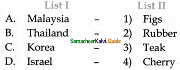
Codes:
(a) 2, 3, 4, 1
(b) 4, 3 , 2, 1
(c) 4, 3, 1, 2
(d) 2, 3, 1, 4
Answer:
(a) 2, 3, 4, 1
Question 5.
India is the leading producer of ______
(a) Zinc
(b) Mica
(c) Manganese
(d) Coal
Answer:
(b) Mica
Question 6.
The natural boundary between Spain and France is ……………
(a) The Alps
(b) The Pyrenees
(c) The Carpathian
(d) The Caucasus
Answer:
(b) The Pyrenees
![]()
Question 7.
The western and north-western Europe enjoys mild and humid climate.
Choose the correct option:
(a) These regions are found near the equator
(b) It is influenced by the North Atlantic Drift
(c) It is surrounded by mountains
(d) All of the above
Answer:
(b) It is influenced by the North Atlantic Drift
Question 8.
Which of the following statements is incorrect?
(a) Europe produces electricity from hydel power.
(b) All the rivers of Europe originate in the Alps.
(c) Most of the rivers in Europe are used for inland navigation.
(d) The fivers of Europe are perennial in nature.
Answer:
(b) All the rivers of Europe originate in the Alps.
Question 9.
Choose the incorrect pair.
(a) The Meseta – Spain
(b) The Jura – France
(c) The Pennine – Italy
(d) The Black Forest – Germany
Answer:
(c) The Pennines – Italy
Question 10.
Which country in Europe has a very low density of population?
(a) Iceland
(b) The Netherlands
(c) Poland
(d) Switzerland
Answer:
(a) Iceland
II. Fill in the blanks
- The Taurus and the Pontine ranges radiate from the …………….
- The wettest place in the world is …………….
- Iran is the largest producer of ……………. in the world.
- Europe connected with south and south east Asia by …………….
- The national dance of Philippines is …………….
- The second highest peak in Europe is …………….
- The type of climate that prevails in the central and eastern parts of Europe is …………….
- The important fishing ground in North Sea is ……………..
- The density of population in Europe is ……………..
- The river ……………. passes through nine countries of Europe.
Answer:
- Armenian
- Mawsynram
- dates
- the Suez canal
- Tinikling
- the Mont Blanc
- Continental type
- Dogger Bank
- 34 persons/Km2
- Danube
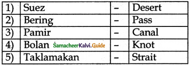
III. Match the following
Answer:
1. – d
2. – a
3. – e
4. – b
5. – c
IV. Let us learn
Question 1.
Assertion (A) : Italy has dry summers and rainy winters
Reason (R) : It is located in the Mediterranean region
(a) Both A and R are individually true and R is the correct explanation for A
(b) Both A and R are individually true but R is not the correct explanation for A
(c) A is true, but R is false
(d) A is false, but R is true
Answer:
(d) A is false, but R is true
Question 2.
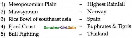
Places marked as 1, 2, 3 and 4 in the given map are noted for the following plains.
(a) Indo – Gangetic plain
(b) Manchurian plain
(c) Mesopotamian
(d) Great plains of China
Match the plains with the notation on the map and select the correct answer using the codes given below.
Codes:
Answer:
b) 2 1 3 4
Question 3.
In the given outline map of Asia, the shaded areas indicate the cultivation of ……………..
(a) Sugarcane
(b) Dates
(c) Rubber
(d) Jute
Answer:
(b) Dates
V. Answer in Brief
Question 1.
Name the important intermontane plateaus found in Asia.
Answer:
The plateau of Anatolia, The plateau of Iran, and the plateau of Tibet are the important intermontane plateaus found in Asia.
Question 2.
Write a short note on the monsoon climate.
Answer:
- The south, southeast and eastern parts of Asia are strongly influenced by monsoon winds.
- Summer is hot and humid while winter is cool and dry.
- The summer monsoon winds bring heavy rainfall to India, Bangladesh, Indo-China, Philippines and Southern China.
![]()
Question 3.
How does physiography play a vital role in determining the population of Asia?
Answer:
- In Asia, the population is unevenly distributed because of various physical features.
- China and India alone cover three-fifth of Asia’s population.
- River plains and industrial regions have a high density of population, whereas low density is found in the interior parts of Asia.
Question 4.
Name the ports found is Asia.
Answer:
Tokyo, Shanghai, Singapore, Hong Kong, Chennai, Mumbai, Karachi and Dubai are the important seaports in Asia.
Question 5.
Asia is called the ‘Land of Contrasts – Justify.
Answer:
The biggest continent Asia is called “the land of contrasts”.
Because:
- Asia is the biggest continent has different types of land features such as mountain, plateau, plain, valley, bay, island etc.
- It has different climatic conditions from the equator to polar region.
- Apart from this many races, languages, religions and cultures are followed by people who live in Asia. Therefore, Asia is called ‘the land of contrasts’.
Question 6.
Name the important mountains found in the Alpine system.
Answer:
The important mountain ranges in the Alpine system are the Sierra Nevada, the Pyrenees, the Alps, the Apennines, the Dinaric Alps, the Caucasus and the Carpathian.
![]()
Question 7.
What are the important rivers of Europe?
Answer:
The important rivers of Europe are Volga, Danube, Dnieper, Rhine, Rhone, Po, and Thames.
Question 8.
Name a few countries which enjoy the Mediterranean type of climate.
Answer:
The Mediterranean and sub-mediterranean climate regions in Europe are found in much of southern Europe, mainly in southern Portugal, most of Spain, the southern coast of France, Italy, the Croatian Coast, much of Bosnia, Montenegro, Kosovo, Serbia, Albania, Macedonia, Greece and the Mediterranean Islands.
Question 9.
Give a short note on the population of Europe.
Answer:
- Europe is the third-most populous continent, after Asia and Africa. The population density in Europe is.34 persons / km2.
- High population density is often associated with the coalfields of Europe.
- Other populous areas are sustained by mining, manufacturing, commerce, offering large market, labour forces and productive agriculture.
- Monaco, Malta, San Marino, and the Netherlands are the most densely populated countries; Iceland and Norway have a very low density of population.
Question 10.
Name the important festivals celebrated in Europe.
Answer:
- The Europeans celebrate both religious and holiday festivals.
- Christmas, Easter, Good Friday, the Saint Day, Redentore, Tomatina and Carnival are the important festivals of Europe.
VI. Distinguish
Question 1.
Intermontane plateaus and southern plateaus.
Answer:
Intermontane plateaus:
- Intermontane plateaus are found in the mountain ranges.
- Eg, The plateau of Anatolia, The plateau of Iran, and the plateau of Tibet
Southern plateaus:
- The southern plateaus are relatively lower than the northern plateaus.
- Eg. Arabian Plateau, Deccan Plateau, Shan Plateau, and the Yunnan Plateau.
Question 2.
Cold desert and hot desert.
Answer:
Cold desert:
- A barren or desolate area especially sandy region of little rainfall, featuring cold dry winter.
- Cold deserts are found in the antarctic, Green land, Western China, Turkartan the Gopi crodi desert in Mongolia.
Hot desert:
- A barren or desolate area often the sandy region of little rainfall.
- The largest hot desert is the Sahara desert.
![]()
Question 3.
Tundra and Taiga.
Answer:
Thunder:
- The Arctic and northern Scandinavian highland have Tundra type of vegetation.
- The winters are very long and severe summers are very short and warm.
- It is the land with few animals like polar bear, reindeer and walrus
- No trees. Lowest form of vegetation like Mosses and Lichen only available.
Taiga:
- They are found in the south of the Tundra region in Norway, Sweden, Finland, Germany, Poland and Austria.
- The winters are long and cold. Summers are short and warm.
- It is the land of fur bearing animals. Eg. Mink, silver fox, squirrel etc.
- Pine, fir, spruce and larch are the important tree varieties.
Question 4.
The North-Western highlands and Alpine mountain range
Answer:
The North-Western Highlands:
- This region includes the mountains and plateaus of Norway, Sweden, Finland, Scotland, and Iceland.
- This region has a fjord coast. It was created by glaciations.
- A lot of lakes here serve as reservoirs for producing hydroelectricity.
The Alpine mountain range:
- The Alpine mountain system consists of a chain of young fold mountains found in the southern part of Europe.
- The Sierra Nevada, the Pyrenees, the Alps, the Apennines, the Dinaric Alps, the Caucasus and the
- Carpathian is the important mountain ranges.
- The Pyrenees is a natural boundary between Spain and France.
VII. Give Reasons
Question 1.
Asia is the leading producer of rice.
Answer:
Because:
- In Asia, India has the largest area of arable lands.
- Agriculture is intensively practiced in the riverine plains of Asia
- China and India are the leading producers of rice in the world.
Question 2.
Asia is the largest and most populous continent in the world.
Answer:
Because:
- Most of the land of Asia in the northern hemisphere has different physical and cultural features.
- Lofty mountains, plateaus, plains, islands and peninsulas are the major physiographic features.
- Many perennial rivers flow through different parts. These river valleys are the cradles of ancient civilizations.
- River plains and industrial regions have high density of population. Population density 143 persons/Km2.
- Asia covers about 30 percent of the world’s population.
![]()
Question 3.
Although Western Europe is located in the high latitudes, it has a moderate climate.
Answer:
Because:
- The western part has a mild, generally humid climate, influenced by the North Atlantic Drift.
- North Atlantic Drift is a Warm ocean current which brings warmth to the Western Europe.
VIII. Answer in Paragraph
Question 1.
Give an account of the drainage system in Asia.
Answer:
- The rivers of Asia originate mostly from the central highlands.
- The Ob, Yenise and Lena are the major rivers flow towards the north and drain into the Arctic Ocean. They remain frozen during winter.
- Many perennial rivers like Brahmaputra, Indus, Ganga and Irrawaddy originate from the high mountains.
- They do not freeze during winter.
- The Euphrates and Tigris flow in west Asia.
- The Amur, Huang He, Yangtze and Mekong flow in the south and southeastern parts. The Yangtze is the longest river in Asia.
Question 2.
Describe the mineral sources found in Asia.
Answer:
- Asia has a variety of mineral deposits like Iron, Coal, Manganese, Bauxite, Zinc, Tungsten, Petroleum, Tin etc. Oil and Natural Gas found in the west Asian countries.
- Iron Ore: Asia has the largest deposits of iron ore in the world. China and India are the important iron ore deposit countries of Asia.
- Coal: Coal is a fossil fuel. China and India are the largest producers of coal in Asia.
- Petroleum: Petroleum is a mineral oil. The largest petroleum reserves are found in South West Asia. The important petroleum-producing countries are Saudi Arabia, Kuwait, Iran, Bahrain, Qatar and UAE.
- Bauxite is found in India and Indonesia.
- Mica: India is the largest producer in the world.
- Tin is found in Myanmar, Thailand, Malaysia, and Indonesia.
Question 3.
What are fjords? How do they protect harbours from bad weather conditions?
Answer:
- A fjord is a narrow and deep-sea inlet between steep clifts.
- Fjords reduce the speed of wind irrespective of their direction.
- The force of sea waves is also controlled.
- Fjord coast was created by glaciations in the past.
- Areas with fjords are best suited for natural harbours. Example : Norway.
![]()
Question 4.
Describe the climatic divisions of Europe.
Answer:
- The climate of Europe varies from the subtropical to the polar climate.
- The Mediterranean climate of the south has warm summer and rainy winter.
- The western and northwestern parts have a mild, generally humid climate, influenced by the North Atlantic Drift.
- In central and eastern Europe, the climate is humid continental-type.
- In the northeast, subarctic and tundra climates are found.
- The whole of Europe is subject to the moderating influence of prevailing westerly winds from the Atlantic Ocean.
- North Atlantic Drift is a warm ocean current which brings warmth to Western Europe.
- The westerly wind further transports warmth across Europe.
X. Activity
Question 1.
Complete the following
I belong to ………… district. My district is famous for the following : …………, ………… and ………… . The boundaries of my districts are in the north, in the east, in the south and in the west. It spreads for an area of km2. There are ………… taluks and ………… villages in my district. …………, …………, ………… are the important mountain / plain / plateaus (If all, mention all features). The rivers …………, ………… ………… criss – cross my district. …………, …………, ………… are common trees and wildlife such as, are found here. …………, …………, ………… are important minerals available in my district. Based on this …………, ………… industries are located here. The major crops are …………, …………, ………… . (Coastal districts may write the variety of fish). The total population is …………. We celebrate …………, …………, ………… festivals.
Answer:
Tirunelveli, Nellaiyappar Temple, Courttalam, Halwa, Virudhunagar, Tuticorin, Kanyakumari, Western Ghats, 6823sq.kms, 16 taluks, 559 Villages, Thamirabarani, Chittar, Manimuthar, Palm, Neem, Cocount, Monkeys, Tigers, Elephants, Bluemetal, Lime stone, Thorium, Cement, Ginning, Vessels, Paddy, Cotton, Sugarcane, 33, 22, 644, Pongal, Deepavali, Christmas.
Question 2.
If you get a chance to settle in Europe, which country would you choose? List out the reasons why?
Question 3.
Choose any region is Asia. In the map of Asia, mark its distribution of natural vegetation and wildlife. Paste related pictures.
Samacheer Kalvi 6th Social Science Asia and Europe Additional Important Questions and Answers
I. Choose the Correct Answer
Question 1.
……………. separates Asia from Africa
(a) Suez Canal
(b) Bering Strait
(c) Mediterranean Sea
(d) Palk Striat
Answer:
(a) Suez Canal
Question 2.
Shan plateau is located in ______
(a) Saudi Arabia
(b) Myanmar
(c) India
(d) China
![]()
Question 3.
The South Asian rivers
(i) remain frozen during winter
(ii) flow towards the north
(iii) are perennial
Of the statements given above
(a) i alone is correct
(b) iii alone is correct
(c) All the three are correct
(d) All the three are wrong
Answer:
(b) iii alone is correct
Question 4.
Find out the wrong pair.
(a) Coal – China
(b) Iron ore – India
(c) Bauxite – Iran
(d) Tin – Myanmar
Answer:
(c) Bauxite – Iran
Question 5.
River yangtze flows in ……………
(a) Inida
(b) Japan
(c) Myanmar
(d) China
Answer:
(d) China
![]()
Question 6.
The light house of the Mediterranean is ______
(a) Mt. Stromboli
(b) Mt. Etana
(c) Mt. Vesuvius
(d) None of the above
Question 7.
Choose the incorrect pair:
(a) Siberian Plain – Ob, Yenisey
(b) Manchurian Plain – Amur
(c) Greet plain of China – Yangtze, Sikiang
(d) Mesopotamian Plain – Irrawaddy
Answer:
(d) Mesopotamian Plain – Irrawaddy
II. Match the following
Answer:
1. – c
2. – e
3. – d
4. – b
5. – a
III. True/False
- There are two knots found in Asia.
- Ob, Yensie, Lena remain frozen during winter
- Teak, Sandal wood are coniferous trees
- The fjord region has a lot of lakes
- Wheat is the dominant crop throughout Europe.
Answer:
- True
- True
- False
- True
- True
IV. Answer in Brief
Question 1.
What are the cradles of ancient civilization? Why?
Answer:
- The river valleys are the cradles of civilizations.
- Because the ancient civilizations Indus valley, Mesopotamian and Chinese civilizations were born in Asian river valleys.
Question 2.
Mention the Physical divisions of Asia.
Answer:
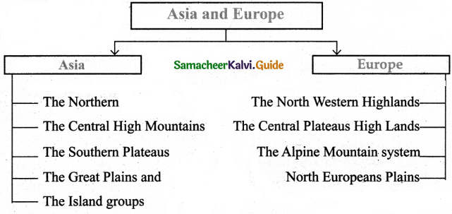
The physical divisions of Asia are
- The Northern lowlands
- The Central High Mountains
- The Southern Plateaus
- The Great Plains and
- The Island Groups.
Question 3.
What are the rare species found in Asia?
Answer:
- Orang – Utan
- Komodo Dragon
- Giant Panda
![]()
Question 4.
Mention the Great Plains of Asia.
Answer:
The great plains of Asia are
- West Siberian plain (Ob and Yenisey)
- Manchurian Plain (Amur)
- Great Plain of China (Yangtze and Sikiang)
- Indo-Gangetic Plain (Indus and Ganga)
- Mesopotamian plain (Tigris and Euphrates) and
- The Irrawaddy plain (Irrawaddy)
Question 5.
Name the countries where fishing is a large industry.
Answer:
- Norway
- Iceland
- Russia
- Denmark
- The United Kingdom
- The Netherlands
V. Give Reasons
Question 1.
Europe is a modern and economically developed continent.
Answer:
Avilability of sources, efficient educated work force, research, contact with other nations and innovations are the factors that transformed like this.
Question 2.
Varied patterns of agricultural activities are in use in Europe.
Answer:
- Europe is an industrially developed continent. It has great diversity in its topography, climate and soil.
- These interact to produce varied patterns of agriculture activities.
[The varied patterns of agriculture activities in use: Mediterranean agriculture, Dairy farming, mixed livestock, crop farming, horticulture]
![]()
Question 3.
There is no winter in the equatorial region.
Answer:
The areas found in and around the equator of Asia have uniform climate throughout the year. There is no winter. Average temperature 27°c. The mean rainfall 1270 mm.
VI. Answer in Paragraph
Question 1.
Describe Industries in Europe.
Answer:
- Large scale Industries : Steel and Iron are, Ship building, Motor vehicle, Aircraft construction, Pharmaceutical drugs.
- Small scale Industries that produce nondurable goods are found throughout Europe.
- Some countries have a reputation for speciality goods.
- Bicycles – English, Italian and Dutch
- Glass – Swedish and Finnish
- Perfumes and fashion goods – Parisian
- Precision instruments – Swiss
VII. Mind map