Students can download 10th Social Science Geography Chapter 5 India: Population, Transport, Communication, and Trade Questions and Answers, Notes, Samacheer Kalvi 10th Social Science Guide Pdf helps you to revise the complete Tamilnadu State Board New Syllabus, helps students complete homework assignments and to score high marks in board exams.
Tamilnadu Samacheer Kalvi 10th Social Science Solutions Geography Chapter 5 India: Population, Transport, Communication, and Trade
Samacheer Kalvi 10th Social Science India: Population, Transport, Communication, and Trade Text Book Back Questions and Answers
I. Choose the correct answer
Question 1.
The scientific study of different aspects of population is called:
(a) Photography
(b) Demography
(c) Choreography
(d) Population density
Answer:
(b) Demography
Question 2.
The state with highest literacy rate as per 2011 census is ……..
(a) Tamil nadu
(b) Karnataka
(c) Kerala
(d) Uttarpradesh
Answer:
(c) Kerala
Question 3.
Human Development is measured in terms of:
(a) Human Resource Index
(b) Per capita index
(c) Human Development Index
(d) UNDP
Answer:
(c) Human Development Index
![]()
Question 4.
……… Transport provides door to door services.
(a) Railways
(b) Roadways
(c) Airways
(d) Waterways
Answer:
(b) Roadways
Question 5.
The length of Golden Quadrilateral superhighways in India is:
(a) 5846 km
(b) 5847 km
(c) 5849 km
(d) 5800 km
Answer:
(a) 5846 km
Question 6.
The length of navigable Inland waterways in India is ……..
(a) 17,500 km
(b) 5000 km
(c) 14,500 km
(d) 1000 km
Answer:
(c) 14,500 km
Question 7.
The National Remote sensing Centre(NRSC) is located at:
(a) Bengaluru
(b) Chennai
(c) Delhi
(d) Hyderabad
Answer:
(d) Hyderabad
![]()
Question 8.
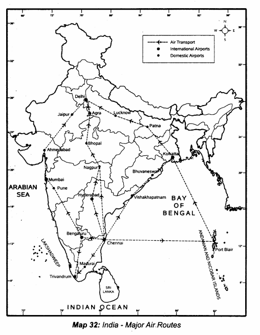
The transport useful in the inaccessible areas is ……..
(a) Roadways
(b) Railways
(c) Airways
(d) Waterways
Answer:
(c) Airways
Question 9.
Which of the following is associated with helicopter service?
(a) Air India
(b) Indian Airlines
(c) Vayudoot
(d) Pavan Hans
Answer:
(d) Pavan Hans
Question 10.
The major import item of India is
(a) Cement
(b) Jewells
(c) Tea
(d) Petroleum
Answer:
(d) Petroleum
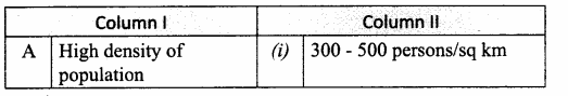
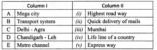
II. Match the following
Question 1.
Match the Column I with Column II.
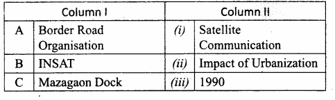
Answer:
A. (v)
B. (i)
C. (iv)
D. (ii)
E. (iii)
![]()
III. Answer the following questions briefly
Question 1.
What is Human Development?
Answer:
It is a process of enlarging the range of people’s choice, increasing their opportunities for education, health care, income and empowerment. It covers a full range of human choices from a sound physical environment to economic, social and political freedom.
Question 2.
What is migration? State its types.
Answer:
Migration is the movement of people across regions and territories. It can be internal (within a country) or international (between the countries). Migration depends on
Push factor: Unemployment and underemployment in rural areas.
Pull factor: higher wages, employment opportunity, industrial development.
Question 3.
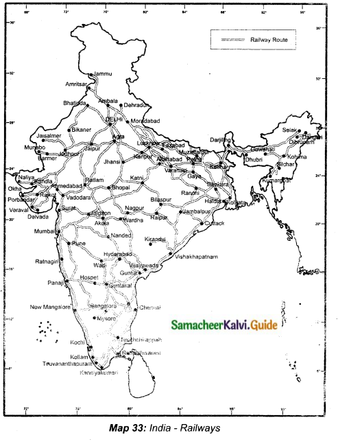
Write any four advantages of railways.
Answer:
- Railways are the price mode of transport for goods and passengers in India.
- They make it possible to conduct varied activities like business, sightseeing and pilgrimage along with transportation of goods over longer distances.
- They are suitable for long-distance travel and play an important role in national integration.
- They bind the economic life of the country as well as the accelerate the development of the industry and agriculture.
Question 4.
Write a note on Pipeline network transport in India.
Answer:
Pipelines are the very convenient transport to connect oil and natural gas fields, refineries and to the markets.
It can be laid through difficult Terrain as well as under water.
It ensures steady supply of goods and reduces the transhipment loss and delays.
Three important network of pipeline:
- Oil fields in upper Assam and Kanpur.
- From Salaya in Gujarat to Jalandhar in Punjab.
- From Hazira in Gujarat to Jagadispur in Uttar Pradesh
Question 5.
State the major Inland waterways of India.
Answer:
The major inland waters ways of India are :
- National Waterway I: It extends between Haldia and Allahabad, measures 1620 km and includes the stretches of the Ganga – Bhagirathi – Hooghly river system.
- National Waterway 2: This waterway includes the stretch of the Brahmaputra river between Dhubri and Sadiya a distance of 891 km.
- National Waterway 3: This waterway extends between Kollam and Kottappuram in the state of Kerala. It is the first national waterway in the country with 24 hour navigation facilities along its entire stretch of 205 km.
Question 6.
What is communication? What are its types?
Answer:
Communication is a process that involves exchange of information, thoughts , and ideas. lt is categorized into two types.
Personal Communication: Post and telegraph, telephone, mobile phone, short message services, fax, internet, e-mail etc.
Mass Communication: Electronic media-Radio, T.V, internet and print media-News papers.
![]()
Question 7.
Define “International trade”.
Answer:
When trade takes place between two countries it is known as international trade.
Question 8.
State the merits of Roadways.
Answer:
- Roadways can provide door to door services.
- Easy and cheap to construct and maintain. Indian roads are cost-efficient.
- The most universal mode of transport. It is used by all sections of people in society.
- Can establish easy contact between farms, fields, factories and markets.
IV. Distinguish between
Question 1.
Density of population and Growth of population.
Answer:
Density of Population:
- Density of population is the number of persons living per square kilometre.
- It is calculated per 1000.
- As per 2011 census the average density of population in India is 382 persons living in per sq.km.
Growth of Population:
- Growth of population refers to the change in the number of in habitants of a country/territory in a specific period of time.
- It is expressed in percentage.
- The year 1921 is called the year of Great Demographic Divide.
Question 2.
Persona! communication and Mass communication.
Answer:
Personal communication:
- Exchange of communication between the individuals.
- Enables the user to establish direct contact.
- It includes post and telegraph, telephones, mobile phones, short message service (SMS) fax, Internet, e-mail etc.
Mass communication:
- Millions of people get the information at the same time.
- Provide information through print media and electronic media.
- It includes Radio, Television and Internet. Electronic media, News paper, Magazines, books, journals etc.
Question 3.
Print Media and Electronic Media.
Answer:
Print Media:
- Most powerful means of communication.
- Many news papers carry information on local national and international events to the people.
- Knowledge of reading is essential.
Electronic Media:
- Communication to millions of people through electronic gadgets at the same time.
- Radio, Television, Internet provide and create awareness on various national policies and programme.
- A powerful audio-visual medium.
![]()
Question 4.
Roadways and Railways.
Answer:
Roadways:
- Highly suitable for short distance services.
- Most common mode of transport, easy, cheap to construct and maintain.
- Based on the construction and maintenance divided into National Highways, State Highways, District Roads, Village roads, Border roads, International highways, Express ways.
- Second longest network in the world.
- Door to door services possible
Railways:
- Ideal for long distance services.
- Construction depend upon the climatic and physical factors like terrain. Costly when compared with roadways.
- On the basis of width of the track falls under 4 types, Broad gauge, meter gauge, narrow gauge and light gauge.
- Largest in Asia and second largest in the World.
- Cannot provide door to door services.
Question 5.
Waterways and Airways.
Answer:
Waterways:
- Oldest and Cheapest means of transport.
- Most suitable for carrying heavy and bulky materials.
- Two types, inland waterways-river and backwaters and canals and oceanic routes connect coastal areas.
Airways:
- Modem and costliest means of transport.
- Only limited weight can be carried. Cannot carry heavy and bulky materials.
- Domestic air sendee within the country and International Airways connect major cities of the World.
Question 6.
internal trade and International trade.
Answer:
Internal trade:
- Trade is carried on within the domestic territory.
- Land transport plays a major role (Roadways and Railways).
- Local currency is used.
- Helps to promote a balanced regional growth.
International trade:
- Trade is carried on between two or more countries.
- Waterways and Airways play a vital role.
- Foreign currency is involved.
- Helps to promote country’s economy and raise the standard of living
![]()
V. Answer the following in a paragraph
Question 1.
What is urbanization? Explain its impacts.
Answer:
The process of society’s transformation from rural to urban is known as urbanization. The level of urbanization of a place is assessed based on the size of population of the towns and cities and the proportion of population engaged in non agricultural sectors. These two are closely linked to the process of industrialization and expansion of the secondary and tertiary sectors of economy.
Impacts of urbanization:
- Urbanization and population concentration go hand – in – hand and are closely related to each other. A rapid rate of urbanization in a society is taken as an indicator of its economic development.
- Urbanization is increasing rapidly in the developing countries including India.
- Rural to urban migration leads to population explosion in urban areas. Metropolitan cities like Mumbai, Kolkatta and Delhi have more population than that can accommodate.
The following are the major problem of urbanization in India. - It creates urban sprawl.
- It makes overcrowding in urban centres.
- It leads to shortage of houses in urban areas.
- It leads to the formation of slums.
- It increases traffic congestion in cities.
- It creates water scarcity in cities.
- It creates drainage problems.
- It poses the problem of solid waste management.
- It increases the rate of crime.
Question 2.
Explain the importances of satellite communication in India.
Answer:
- The communication through satellites emerged as a new era in the system of communication in our country.
- The use of Satellite in getting a continuous and synoptic view of larger area has made this communication system very vital for the country.
- Satellite images are used for weather forecasting.
- Monitoring of natural calamities.
- Surveillance of border areas.
- The INSAT (series) is a multipurpose system for telecommunication, meterological observation and for various other programs.
- They are used for relaying signals to television, telephone, radio and mobile phone.
- And also useful in weather detection, internet and military applications.
![]()
Question 3.
Bring out the distribution and density of population in India.
Answer:
The term ‘Population Distribution’ refers to the way the people are spaced over the earth’s surface. The distribution of population in India is quite uneven because of the vast variation ki the availability of resources. The population is mostly concentrated in the regions of industrial centres and the good agricultural lands. On the other hand, the areas such as high mountains and lands thickly forested areas and some remote comers are very thinly populated and some areas are even uninhabited.
Terrain, climate, soil, water bodies, mineral resources, industries, transport and urbanization are the major factors which affect the distribution of population in our country. Population density is a better measure of understanding the variation in distribution of population. It is expressed as number of person per unit area usually per sq.km. According to 2011, the average density of population of India is 382 person per sq.km. India is one of the most thickly populated ten countries of the world. The most densely populated state of India is Bihar and the state with lest population density is Arunachal Pradesh. Among union territories, Delhi is the densely populated one with 11,297 per sq.km, while Andaman and Nicobar Islands have the lowest density of population.
Question 4.
Explain the process of measuring Human Development.
Answer:
Dr. Mahabub-ul-haq defined Human Development as “It is a process of enlarging the range of people’s choice, increasing their opportunities for education, health care, income and empowerment. It covers the full range of human choices from a. sound physical environment to economic, social and political freedom”.
Measuring of Human Development (HDI): Human Development Index is a composite index focusing on three basic dimensions of human development.
- Health: Life expectancy at birth.
- Education: Expected years of schooling for school age children and average years of schooling for the adult population.
- Income: Measured by gross national income and per capita income.
Question 5.
Classify and explain the roadways in India.
Answer:
- The Indian roads are cost-efficient and the most popular dominant mode of transport
linking different parts of our country. - Roads stretch across the length of people in society.
- It is used by all sections of people in society.
- Road network in India is the second-longest in the world accounting for 3,314 millions of km.
Types of Roadways:
1. Village Roads:
- Village roads link different villages with towns.
- They are maintained by Village Panchayath.
- In India village roads run to a length of 26,50,000 kms.
2. District Roads:
- District roads link the towns with the district headquarters.
- They are maintained by the Corporations and Municipalities.
- It is used by all sections of people in the society.
- In India district roads run to a total length of 4,67,763 kms.
3. State Highways:
- State Highways links the State capitals with the different district headquarters.
- These roads are maintained by the State Public Works Department.
- The State Highways run to a length of 1,31,899 kms. (Ex: Cudalore – Chittor Road).
4. National Highways:
- National Highways link the State Capitals with the National Capital.
- They are the primary road system of our country and are maintained by the Central Public Works Department.
- It runs to a length of 70,548 kms. (Ex: NH47 is a National Highway which connects Tamil Nadu and Kerala)
5. Golden Quadrilateral Super Highways:
- It is a major road development project launched by the Government of India.
- It runs to a length of 14,846 kms connecting the major cities of India.
- The major objective of these roads is providing ‘connectivity’, ‘speed’ and ‘safety’.
6. Expressways:
- Expressways are the technologically improved high class roads in the Indian Road network.
- They are six lanes roads. They run to a length of more than 200 kms.
- New Mumbai – Pune Road is an example for Expressway.
7. Border Road:
- Border Roads are the roads constructed along the northern and north eastern borders of our country.
- These roads are constructed and maintained by Border Roads Organization.
- The Organization has constructed 46,780 km of roads in difficult terrain.
8. International Highways:
International Highways are the roads that link India with neighbouring countries for promoting harmonious relationship with them.
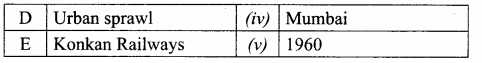
VI. On the outline map of India mark the following
Question 1.
National Highway NH-7.
Answer:
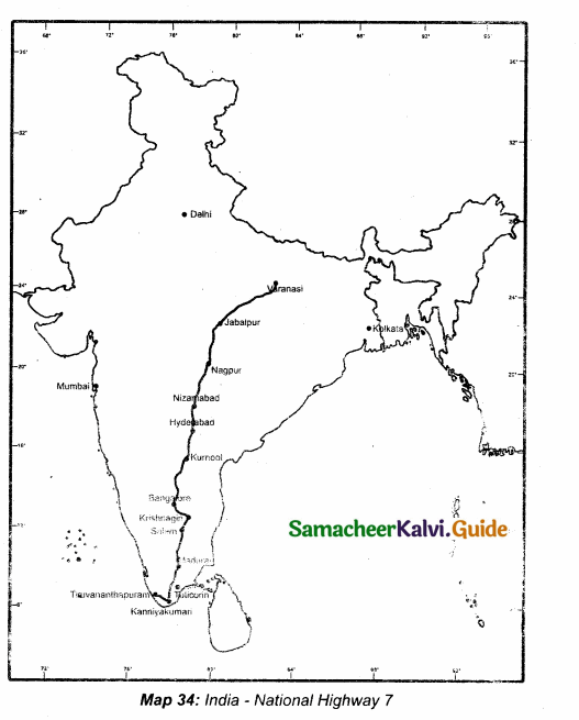
Question 2.
Major seaports in India.
Answer:
Question 3.
Major International Airports in India.
Answer:
![]()
Question 4.
Densely populated state of India – Uttarpradesh
Answer:
Question 5.
State of highest literacy in India – Kerala
Answer:
Question 6.
Railways zones of India.
Answer:
TB Page No. 151
Hots:
Question 1.
What could be the reasons for uneven distribution of population in India?
Answer:
- Topography, favourable climate, fertility of soils, availability of fresh water, minerals are major geographical factors affecting population density of a region.
- People prefer to live on plains more than mountains or plateaus and they live more in moderate climates than extreme hot or cold. From the agriculture point of view, fertile lands are preferred.
- Areas with mineral deposits are more populated.
- Some social factors that boost the density of population in a region are better housing, education and health facilities.
- Places with cultural or historical significances are usually populated.
- Employment opportunities is another attraction for large chunks of the population.
Question 2.
What are the reasons for the rapid growth of population in India?
Answer:
- The reasons for the rapid growth of population in India is mainly the , high birth rate and low death rate.
- Birth rate is high, death rate declined due to advanced medical facilities and immunization to dreadful diseases.
- And also migration of population due to employment, education and industrial development.
TB Page No. 154
Question 3.
The sex ratio in our country is always unfavourable to females. Give reasons.
Answer:
The number of females per thousand men is called the sex ratio.
Reasons:
- Lesser care of female children.
- Greater risk to womens’ life especially at the time of child brith.
- Women are also killed or forced to die by the dowry seekers.
- Due to illiteracy.
- Lack of medical facilities for women, etc.
TB Page No. 158
Question 4.
Find out what are the functions of NHAI?
Answer:
- National Highway Authority of India was established in 1995.
- It is an autonomous body under the ministry of Surface Transport.
- Management of all major National Highways and the highways entrusted to it.
- Maintenance, development and operation of the National Highways is undertaken by NHAI.
Question 5.
What are the highlights and benefits of the Golden Quadrilateral Highways? Highlights:
Answer:
- It is the largest Highway project completed in India.
- It is the fifth largest highway project in the world.
- The overall length of the Golden Quadrilateral is 5,846 km.
- The Golden Quadrilateral passes through 13 states of India.
- It connects four major metropolitan cities of the country in four directions.
Benefits:
- Provides faster transport networks between major cities and ports.
- Provides connectivity to major agricultural industrial and cultural centres of India.
- Provides smoother movement of goods and people within the country.
- Enables industrial development and job creation in smaller town through access to varied markets.
- Farmers are able to transport their produce to major cities and towns for sale and export and there is less wastage and spoils.
- More economic growth through construction and indirect demand for steel, cement, and other construction materials.
- Giving an impetus to truck transports.
![]()
TB Page No. 162
Question 6.
Why is air travel preferred in the North Eastern State?
Answer:
The North Eastern States are mountainous and forested. So construction of roadways or railways is very difficult due to terrains. Air transport has made accessibility easier. So air travel is preferred in the North eastern states.
TB Page No. 165
Question 7.
Find out the major trade blocs which are useful for multilateral trade.
Answer:
Trading blocs are usually groups of countries in specific regions that manage and promote trade activities. Trading blocs lead to trade liberalisation and trade creation between members, since they are treated favourably in comparison to non-members. The World Trade Organisation (WTO) permits the existence of trading bloc provided that they result in lower protection against outside countries than existed before the creation trading bloc.
The most significant trading blocs currently are:
- European Union (EU): A customs union, a single market and now with a single currency.
- European Free Trade Area (EFTA)
- North American Free Trade Agreement (NFATA) between the USA, Canada and Mexico.
- Mercosur: A customs union between Argentina, Brazil, Paraguay, Uruguay, and Venezuela.
- Association of Southeast Asian Nations (ASEAN)
- Association of Free Trade Area (AFTA)
- Common market of Eastern and Southern Africa (COMESA)
- South Asian Free Trade Area (SAFTA) created in 2006 with countries such as India and Pakistan.
- Pacific Alliance: 2013 – a regional trade agreement between Chile, Colombia, Mexico and Peru.
TB Page No. 159
Activity:
Question 1.
Prepare a seminar topic about “Role of Railways in Indian Economy”Key Points:
Answer:
- Large scale movement
- National integration promotion
- Commercialisation of agriculture
- Movement of perishable goods
- Avoids traffic congestion how?
- Engineering marvel
- Quiz regarding railways
![]()
TB Page No. 165
Question 2.
Collect the countries names and make it as a table of Bilateral trade and multilateral trade countries.
Answer:
India has made bilateral trade agreement with these countries.
Bilateral Trade Countries: U.S.A . China, Hongkong, Singapore, United Kingdom, Germany, Bangladesh.
Multilateral Trade Countries: The members of the SAARC (South Asian Association for Regional Cooperation) Korea, Japan, Bangladesh, Bhutan, Maldives, Nepal, Pakistan, Afghanistan, Srilanka, U.S.A and United Kingdom.
Samacheer Kalvi 10th Social Science India: Population, Transport, Communication, and Trade Additional Important Questions and Answers
I. Choose the correct answer
Question 1.
…………………. is the second-most populous country next to China.
(a) India
(b) Pakistan
(c) Bangladesh
(d) Nepal
Answer:
(a) India
Question 2.
The fast movement of traffic are established by ……
(a) national highways
(b) Express highways
(c) International highways
Answer:
(a) national highways
Question 3.
As per 2011 census the average density of population of India is …………………. persons per Sq.Km.
(a) 302
(b) 382
(c) 100
(d) 365
Answer:
(b) 382
Question 4.
The ………. have more railways than the Himalayan Mountains.
(a) Northern Plains
(b) Coastal Plains
(c) Deccan Plateau
Answer:
(a) Northern Plains
Question 5.
The Grand Trunk Road extends from …………………. to ………………….
(a) Delhi to Mumbai
(b) Amritsar to Kolkatta
(c) Mumbai to Thane
(d) Srinagar to Amritsar.
Answer:
(b) Amritsar to Kolkatta
Question 6.
The cheapest mode of transport is …….
(a) roadways
(b) railways
(c) waterways
Answer:
(c) waterways
Question 7.
…………………. are multi-lane good quality highways for high speed traffic.
(a) National Highways
(b) State highways
(c) Border roads
(d) Express highways.
Answer:
(d) Express highways.
Question 8.
Trade carried on within the domestic territory of a country is known as …… trade.
(a) External
(b) Foreign
(c) Internal
Answer:
(c) Internal
Question 9.
The …………………. railway accounts for the longest route length.
(a) Northern Railways
(b) Central Railway
(c) Eastern railway
(d) Southern Railway
Answer:
(a) Northern Railways
Question 10.
A cost-efficient and most popular mode of transport in our country is ……..
(a) Airways
(b) Roadways
(c) Waterways
Answer:
(b) Roadways
![]()
Question 11.
India is the …………………. largest ship owning country in Asia.
(a) First
(b) Second
(c) Third
(d) Fourth
Answer:
(b) Second
Question 12.
The costliest and most modem means of transport is ……..
(a) Air transport
(b) Road transport
(c) Rail transport
Answer:
(a) Air transport
Question 13.
The is the first communication Satellite in INSAT Series.
(a) G.SAT
(b) EDUSAT
(c) INSAT-IB
(d) Kalpana-1
Answer:
(c) INSAT-IB
Question 14.
The major ports are managed and controlled by …….
(a) National Ports Corporation
(b) Port Trust of India
(c) Indian Airlines
Answer:
(b) Port Trust of India
Question 15.
Indian space Research organisation was established in the year:
(a) 1959
(b) 1969
(c) 1979
(d) 1996
Answer:
(b) 1969
![]()
II. Match the following
Question 1.
Match the Column I with Column II.
Answer:
A. (v)
B. (iv)
C. (i)
D. (iii)
E. (ii)
Question 2.
Match the Column I with Column II.
Answer:
A. (iii)
B. (iv)
C. (v)
D. (i)
E. (ii)
![]()
III. Answer the following questions briefly
Question 1.
Describe the three population density zones of India.
Answer:
The three population density zones of India are :
- High-density zone: The Northern plains above 500 people per sq.km. Northern plains and Kerala in the. South.
- Moderate or Medium density zone: Mountain region 250-500 people per sq.km. Ex. Assam and Peninsular states.
- Low-density zone: Plateau region below 250 people per sq.km. Ex. Jammu and Kashmir, Sikkim, Arunachal Pradesh.
Question 2.
What are the reasons for the uneven distribution of population in India?
Answer:
The uneven distribution of population in the country is the result of several factors such as physical, socio-economic and historical factors.
Physical factors: Relief, climate, water, natural vegetation, minerals and energy resources.
Socio-economic factors: Religion, culture, political issues, economy, human settlements, transport network, industrialization, urbanization, employment opportunity etc.
Question 3.
What is the major objective to develop the Super Highways?
Answer:
The major objective to develop the Super Highways is to reduce the time and distance between
the megacities of India facilitating the fast movement of traffic.
Question 4.
Which phase period in population growth of India is often referred as period of population explosion?
Answer:
During the third phase (1951-1981) the population of India grew from 361 million in 1951 to 683 million in 1981. Growth rate in this period is almost doubled. So this period (1951-1981) is often referred as the period of “population explosion”.
Question 5.
State some problems of road transport in our country.
Answer:
- Distribution of road is not uniform in the country.
- Keeping in view the volume of traffic and passengers, the road network is inadequate.
- About half of the roads are unmetalled and this restricts their usage during the rainy season.
- The roadways are highly congested in cities.
- Poor maintenance is also a big problem.
Question 6.
What are the four major shipyards in India?
Answer:
India as four major shipyards:
- Hindustan shipyard – Vishakapatnam
- Garden Reach workshop – Kolkata
- Mazagaon Dock – Mumbai
- Kochi shipyard – Kochi
Question 7.
State the highlights of India’s foreign trade policy since 2004.
Answer:
- Merchandise trade has been doubled.
- Thrust is given for employment generation; especially in semi-urban and rural areas.
- Trade procedure is simplified and transaction cost is reduced.
- Special focus is given to make India a global hub.
- A new scheme called Vishesh Krishi Upay Yojna has been introduced to boost exports of fruits, vegetables, flowers and minor forest products.
Question 8.
Mention the services provided by the Indian postal system in India.
Answer:
Pcstai system is one among the personal communication system. The postal service was open to the public in the country in 1837.
- Collecting and delivering mail is the primary function of the postal department.
- It introduced Quick Mail Service in 1975 on the basis ofPIN code (1972)
- The premium products include the Money order. E-money order, Speed post. Express parcel post, Business post, Media post, Retail post, Data post, Satellite post, Greeting post, Speed net and Speed passport services,
Question 9.
What are the advantages of communication network?
Answer:
- It has enhanced the efficiency of communication. Because it enables quick exchange of information with people any where in the world.
- It leads to enormous growth of trade.
- It helps the government to tackle various socio – economic problems in the society.
- It improves the quality of human life.
- It opens the door to the information age.
- It promotes Edusat programs.
- It plays a significant role in the economic and social growth of our country.
Question 10.
Write the full form of STD, ISD, PCO, Internet.
Answer:
- STD – Subscriber Trunk Dialing
- ISD – International Subscriber Dialing
- PCO – Public Call Office
- Internet – Inter connected network.
![]()
Question 11.
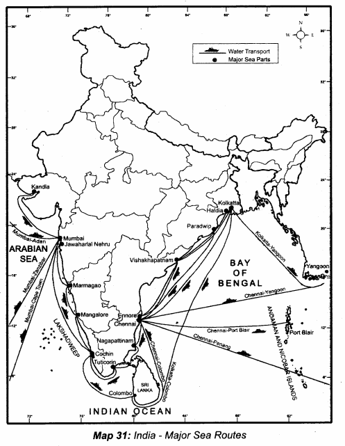
What are major ports along the West Coast and East Coast?
Answer:
West Coast Ports :
- Kandla,
- Mumbai,
- Jawahar Lal Nehru,
- Marmagoa,
- New Mangalore and
- Cochin East Cost Ports:
- Tuticorin,
- Chennai,
- Ennore,
- Vishakhapatnam,
- Paradip,
- Haldia and
- Kolkota.
Question 12.
Name the major ports on the East coast and on the West Coast of India.
Answer:
There are 13 major ports in India. They are administered by the Central Government.
- The major ports on the East coast are Kolkata, Haldia, Paradip,Visakhapatnam, Chennai, Ennore and Tuticorin.
- The major ports on the West Coast are Kandla, Mumbai, Nhava Seva (Jawaharial Nehru Port), New Mangalore, Marmagao and Kochi.
Question 13.
Write a short note on Internet.
Answer:
- Internet is a vast network of computers, Internet means interconnected network of net , works.
- It connects many of the world’s business institutions and individuals.
- It enables computer users throughout the world to send and receive messages and information in a variety of forms.
- It is fully a multimedia based system with capacity to deliver pictures, images, video and audio.
- The basic services of internet are e-mail. The World Wide Web and Internet Phone.
![]()
IV. Distinguish between
Question 1.
Exports and Imports.
Exports:
- Goods and services sold for foreign currency.
- Major exports of India are tea, ores and minerals, marine products, textiles etc.
- Value of exports are more than the value of imports favourable balance of trade.
- India exports goods to nearly 190 countries of the world.
Imports:
- Goods and services bought from overseas producers.
- Major imports are petroleum products, gold, telecom instruments.
- Value of imports exceeds value of exports unfavourable balance of trade.
- Imports we get from nearly 140 countries.
Question 2.
Low Density and High Density of population.
Answer:
Low Density of Population:
- Areas that have 150 to 300 persons living per sq.km.
- Extreme climate, high mountains, remote areas, forested regions have low density of population.
- In India Arunachal Pradesh, Sikkim, Mizoram, Andaman and Nicobar islands are some states with low population density.
High Density of Population:
- Areas that have 500 to 1000 persons living per sq.km.
- Favourable climate, plains, employment opportunities, industrial centres area have high density of population.
- Punjab, Tamil Nadu, Uttar Pradesh and Kerala are the states with high population density.
Question 3.
National and State Highways.
Answer:
National Highways:
- Connects Capitals of States, major ports, rail junctions, industrial and tourist centres.
- Ministry of Road transport and Highways of India is responsible development and maintenance.
- Runs to a length of 1,01,011 kms as of 2016.
State Highways:
- Link important cities, towns and district head quarters within the State and connect them with national highways or highways of neighbouring states.
- Administered and financed by state Governments.
- Runs to the length of 1,76,166 kms as of 2016.
Question 4.
Domestic and International Airways.
Answer:
Domestic Airways:
- Fly within the boundaries of the country.
- Indian Airlines provides the domestic air services. NACIL (I)
- There are about 80 domestic airports and about 25 civil enclaves at defence air fields.
International Airways:
- Fly across the world and connect major cities of the world.
- Air India provides international air services. NACIL (A)
- There are 19 designated international airports in the country.
Question 5.
Harbour and Port.
Answer:
Harbour:
- Extensive stretch of deep water near the seashore.
- Vessels can anchor securely.
Port:
- Commercial part of a harbour.
- Facility of loading and unloading of goods and space for the storage of cargo
- Cuddalore, Ennore.
Question 6.
Birth and Death.
Answer:
Birth Rate:
- No. of live Births per 1000 people in a year.
- Also known as Nationality rate.
Death Rate:
- No. of Deaths per 1000 people in a year.
- Also known as Mortality rate.
![]()
V. Answer the following in a paragraph
Question 1.
What is the importance of railway transport?
Answer:
- The Indian Railways have been a great integrating force for more than 150 years.
- They have a network of about 7,112 stations spread over a route length of 66,687 km with a fleet of 11,122 locomotives, 70,241 passenger coaches and 2,54,000 wagons.
- Railways are the prime mode of transport for goods and passengers in India.
- They make it possible to conduct varied activities like business, sightseeing and pilgrimage along with transportation of goods over longer distances.
- They are suitable for long distance travel and play an important role in national integration.
- They bind the economic life of the country as well as accelerate the development of the industry and agriculture.
- The Indian Railways is the largest public sector undertaking in the country. The first train streamed of from Mumbai to Thane in 1853, covering a distance of 34 km.
Question 2.
What do you mean by Census? How it is useful?
Answer:
- Population census is the total process of collecting, compiling, analyzing or otherwise disseminating demographic, economic and social data pertaining at a specific time, of all persons in a country or a well defined part of a country.
- Census is being taken in an interval of ten years.
- The data collected through the census are used for administration, planning, policy making, management and evaluation of various programmes by the government.
- In India 1st census was carried out in the year 1872.
- But the first complete and synchronous census was conducted in 1881 The 2011 census represents the fifteenth census of India.
Question 3.
Describe the importance of pipelines in India. Name three important networks of pipelines transportation in the country.
Answer:
Pipeline transport network is a new arrival on the transportation of India.
- Transport of crude oil, petroleum products and natural gas from oil and natural gas fields to refineries, fertiliser factories and big thermal power plants. ‘
- Even solids can be transported through pipelines when converted into slurry.
- The far inland locations of refineries and gas based fertiliser plants could be transported.
- Initial cost of lying pipelines is high but subsequent running costs are tninimal.
- It rules out trans-shipment losses or delays.
Three important networks of pipeline transportation in the country:
- From oil field in the upper Assam to Kanpur (UP), via Guwahati, Baraumi and Allahabad.
- From Salaya in Gujarat to Jalandhar in Punjab. Via Viramgam, Mathura, Delhi and Sonipat.
- Gas pipeline from Hazira in Gujarat connects Jagdishpur in UP, via Vijaipur in MP.
Question 4.
What are the problems created by over population in India?
Answer:
In India, growing pressure of Population on resource base, created many socio economic, cultural, political, ecological and environmental problems. The population problem varies in space and time and differ from region to region.
Major issues created by the over population are – overcrowding, unemployment and under employment, low standard of living mal nutrition, mismanagement of natural and agricultural resources, unhealthy environment etc.
Question 5.
Write about the significance of Indian Railways.
Answer:
- Indian Railway system is the main artery of the country’s inland transport.
- Indian Railway network is the largest in Asia and second largest in the world.
- Railways are considered as the back bone of the surface transport system of India.
- Significances: It caters to the needs of large scale movement of traffic both for freight and passengers, there by contributing to economic growth.
- It promotes trade, tourism, education etc.
- It promotes national integration by bringing people together.
- Railways help in the commercialization of the agricultural sector by facilitating the quick movements of perishable goods.
- It provides invaluable service by transporting raw materials to industries and finished goods to market.
Question 6.
What is trade? What are the two types of trade? State its components:
Answer:
- Trade is an act (or) process of buying selling or exchanging of goods and services. Trade in general is of two types. They are Internal trade and International trade.
- Internal Trade: Trade carried on within the domestic territory of a country.
- International trade: Trade carried on between two or more countries.
- Exports and imports are the two components of international trade.
- The difference between value of exports and imports is called balance of trade.
- If the value of exports exceeds the value of imports trade is said to be favourable balance of trade.
- If the value of Imports exceeds value of exports it is said to be unfavourable balance of trade.
- The value of currency of a country depends upon the balance of trade of that country.
![]()
VI. On the outline map of India mark the following
Question 1.
North-South corridor
Answer:
Question 2.
East-West corridor
Answer:
Question 3.
Head quarters of Indian Railway – Delhi.
Answer: